Tectonic evolution of the Karaginsky accretion prism, the Bering Sea
D. V. Kovalenko* and I. R. Kravchenko-Berezhnoy**
*Institute of the Lithosphere (ILSAN), Russian Academy of Sciences, Staromonetnyi per. 22, Moscow, 109180 Russia, e-mail: dmitry@ilsan.msk.ru
**Geological Institute (GIN), Russian Academy of Sciences, Pyzhevskii per. 7, Moscow, 109017 Russia
AbstractóRocks from Karaginsky Island yield both prefolding (close-to-original) and postfolding magnetic vectors. The prefolding vectors suggest that the MaastrichtianñPaleocene volcanicñterrigenous sequences of Karaginsky Island formed at about 40∞ N to 55∞ N and originally were not integral to either Eurasia or North America. The geologic blocks rotated insignificantly in a counterclockwise sense in the horizontal, suggesting that the framework of Karaginsky Island arose without major strike-slip motions. Analysis of secondary magnetizations reveals that the development of this framework involved at least two stages of deformation. It must have been during the second stage that the sequences were tilted 45∞ ñ65∞ in WNW and NW directions; this agrees with the NW vergence of the structure of Karaginsky Island.
INTRODUCTION
Most reconstructions for the Bering Sea region consider Karaginsky Island as a part of an accretionary prism. This prism extends from the southern flank of the Malinovsky Range (Govena Peninsula) in the north via Karaginsky Island into the Eastern Ranges of Kamchatka [Zinkevich and Tsukanov, 1992]. The growth of this prism by successive accretion of lithotectonic units of various ages began in EarlyñMiddle Eocene time and continues still due to subduction of oceanic lithosphere [Bogdanov et al., 1982; Chekhovich et al., 1990; Kravchenko-Berezhnoy and Nazimova, 1991].
We have studied paleomagnetically lithotectonic units of different ages forming the Karaginsky accretionary prism in order to assess the direction of plate convergence in this area for different time slices, i.e., to evaluate the contribution and direction of the strike-slip component in the course of subduction.
PALEOMAGNETIC SAMPLING LOCALITIES
On Karaginsky Island, several lithotectonic complexes are recognized (from oldest to youngest): ophiolitic, volcanicñsiliceous, volcanicñterrigenous, sedimentaryñvolcanic, flysch, sedimentary melange, and molasse [Chekhovich et al., 1990] (Units 3, 2, 4, 1, 5, 5, and 6, respectively, of [Kravchenko-Berezhnoy and Nazimova, 1991]). Relationships among these complexes are shown in Fig. 1.
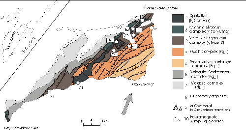 Fig.
1. Geologic scheme of Karaginsky Island (after [Chekhovich et al., 1990]).
1 ó ophiolite complex (K2ConñSan); 2óvolcanicñsiliceous complex
(K2SanñCmp); 3óvolcanicñterrigenous complex
(K2MaañDan); 4óflysch complex (Pg1ñ3); 5ósedimentary
milange complex (Pg1ñ3); 6óvolcanicñsedimentary complex
(Pg2ñ3); 7ómolassic complex (Ng1ñ2); 8óQuaternary deposits;
9aóoverthrusts; 9bósubvertical fractures; 10ópaleomagnetic sampling localities.
Fig.
1. Geologic scheme of Karaginsky Island (after [Chekhovich et al., 1990]).
1 ó ophiolite complex (K2ConñSan); 2óvolcanicñsiliceous complex
(K2SanñCmp); 3óvolcanicñterrigenous complex
(K2MaañDan); 4óflysch complex (Pg1ñ3); 5ósedimentary
milange complex (Pg1ñ3); 6óvolcanicñsedimentary complex
(Pg2ñ3); 7ómolassic complex (Ng1ñ2); 8óQuaternary deposits;
9aóoverthrusts; 9bósubvertical fractures; 10ópaleomagnetic sampling localities.
The ophiolitic rocks were studied in two areas. Near Mt. Shapochka (Fig. 1, locality G1), 11 samples were taken from a layered gabbroic block. On the north of the island, in outcrops along one of the left tributaries of the Severnaya R. (Fig. 1, D1), eight samples were collected from diabase sheeted dikes (one sample per dike).
The volcanicñterrigenous complex was sampled in four localitiesóin the south of the island (north of the Ilkhatunvayam R. mouth; VT in Fig. 1, samples were collected from fine tuffs and from carbonate concretions.) and in the north (near Mt. Khynkhlonai (Fig. 1, VT2, samples were collected from tuffites and tuffaceous siltstones), in the basin of the Voronya R. (Fig. 1, VT3, samples were collected from fine-grained tuffites and from black siltstones and mudstones.), and at one of the tributaries of the Ketonitonvayam R. (Fig. 1, VT4)). Samples were collected from a sequence of alternating fine tuffites and tuffaceous siltstones.
The flysch complex was sampled in two blocks: in sea cliffs to the south of the Severnaya R. (Fig. 1, F1) and on the Yaklekhrivayam R. (tributary to the Markelovskaya R.) (Fig. 1, F2). The F1 sections are composed of black siltstones and mudstones with numerous carbonate concretions, and section F2, of black siltstones and mudstones lacking carbonate concretions. Paleomagnetic samples (44 and 52, respectively) were collected at roughly equal intervals along the sections, from sedimentary rocks and concretions.
LABORATORY TREATMENT OF PALEOMAGNETIC SAMPLES
From each hand sample, two cubes 1 cm or 2 cm on a side were cut out. Each cube was taken to thermal cleaning in the range 20ñ560∞ C, the upper limit being set by the appearance of new-formed magnetic phases that biased the remanence of the cubes. Most cubes were heated 8ñ10 times with steps of 50ñ60∞ C. After each step of the thermal cleaning (hereinafter designated as Jnt), vector directions were measured on a JR-4 magnetometer. The thermal cleaning data from each cube were used to plot Zijderveldís diagrams [Zijderveld, 1967], to perform component analysis of magnetization of the cubes [Kirschvink, 1980] and the analysis of vector distribution over the sphere, etc. For each sample, mean directions for the vectors isolated from both cubes were computed. A sample was rejected if it was impossible to compute mean directions for any of the components with a confidence angle no greater than 25∞ .
All the components were conventionally grouped as hard and soft. Those magnetic components whose removal was accompanied by Jnt vectors clearly moving along great circles were classified as soft. Accordingly, those components whose Jnt vectors form end-points were termed hard. First, for each locality hard and soft components were analyzed separately; in multicomponent Zijderveldís plots, they are recorded jointly, yet they must have different origins. Then, the directions of isolated components were compared with the hard and soft components detected in single-component Zijderveldís plots. In case of coincidence of the areas occupied by hard and soft components isolated in single-component and multicomponent Zijderveldís plots, these hard or, respectively, soft components were grouped into a single population.
All the sequences were divided into blocks that either comprised fault-bounded fragments of sections or fragments of sections with distinctive rock attitudes. The directions of isolated components were analyzed in stereograms separately for each block and jointly for all the sampled blocks or groups of blocks (with similar rock attitudes) in the geographic and stratigraphic reference frames[Khramov et al., 1982].
ANALYZING VECTORS OBTAINED
Rocks from various lithotectonic units of Karaginsky Island yielded several distinctly directed NRM vectors.
Group 1 of the vectors includes soft components coinciding with the present geomagnetic field in the geographic reference frame. These are the MF components obtained from the volcanicñterrigenous complex and NRM components from the parallel dikes of the ophiolitic complex. Apparently, these components are the youngest because they are close to the modern geomagnetic field of the region, and the fold test performed for all the MF components of the volcanicñterrigenous complex (localities VT2, VT3) shows that the MF components postdate folding (N = 24; in geographic reference frame: D = 335, I = 72, K = 8, a95 = 10, FG = 2.16; in stratigraphic reference frame: D = 325, I = 61, K = 5, a95 = 13, FS = 3.29, Fcr = 2.67).
Group 2 comprises secondary reversed-polarity magnetizations approximately antipodal to the geomagnetic field for Karaginsky Island in the geographic reference frame. We attributed to this group NRM components from the ophiolitic layered gabbros and the B components isolated from the VT1 sequence of the volcanicñterrigenous complex. Their origin is assumed to be secondary based on the fact that the gabbroic rocks failed the fold test and on the coexistence in the VT1 locality of soft B components and hard (apparently primary, judging from fold and reversal tests) A components.
Group 3 (probably also secondary) comprises B components that depart drastically from the local geomagnetic field, both direct and reversed. These are B components from localities VT2, VT3, and F1. Their secondary origin is proved by the failed fold tests for localities VT3 and F1. Because these stable, in the geographic reference frame, components are isolated from sections with different rock attitudes (in F1 blocks, rocks dip 45∞ at an azimuth of 185∞ ; in VT3 blocks, rocks dip 30∞ at azimuths of 320∞ , 100∞ , and 60∞ ; in VT2 blocks, rocks dip 25∞ at an azimuth of 230∞ , 15∞ at an azimuth of 150∞ , and 30∞ at an azimuth of 65∞ ) and because they coexist with A vectors of both normal and reversed polarities, these components must be independent, rather than result from summing of different but equally stable components (e.g., A and secondary components of the first two groups).
Lastly, Group 4 includes hard A components isolated from the rocks of the volcanicñterrigenous complex. Their mean directions for all the sampling localities (VT1, VT2, VT3, VT4) are shown in Fig. 9. Rocks from locality VT1 passed fold and reversal tests, and rocks from localities VT2 and VT3 passed fold tests. The regional fold test is positive for localities VT1, VT2, and VT4 (N = 45, DG = 325, IG = 57, KG = 6, a95G = 8, FG = 15.06; DS = 332, IS = 63, KS = 20, a95S = 4.5, FS = 0.3297, Fcr = 2.64). The A components for locality VT3 differ from the other localities, possibly because the blocks at this locality rotated in the horizontal relative to VT1, VT2, and VT4 blocks. However, the fact that the A vector of sequence VT3 is antipodal to the present geomagnetic field and to Group 2 postfolding components as well as the structural setting of the VT3 sections among remagnetized ophiolitic rocks (Fig. 1) suggest a secondary origin for the A component of the VT3 volcanic sequences. These sequences may have acquired a new magnetic overprint as a monoclinally dipping structure to be then deformed once more.
TECTONIC IMPLICATIONS OF PALEOMAGNETIC DATA
From tectonic standpoint, only the B vectors of Group 3 and the A vectors are of interest.
The A vectors (except for those from locality VT3) indicate that the MaastrichtianñPaleocene island-arc sequences on Karaginsky Island formed at about 40∞ ñ55∞ N and are thus likely fragments of either the East Kamchatka island arc or the Olyutorsky island arc; deposits of these arcs are found in the Olyutorsky block [Chekhovich et al., 1990] and in the Kamchatka Isthmus.
Estimates based on Beckís procedure [Beck, 1980; Demarest, 1983] and using paleomagnetic poles for Eurasia and North America [Westphal et al., 1986] show that these sequences were not originally integratal to either Eurasia (F = 19, D F = 6.5) or North America (F = 17, D F = 4.4).
The studied blocks rotated slightly (by 28∞ ± 4.4∞) in a counterclockwise sense in the horizontal relative to the poleward direction, they rotated insignificantly (R = - 15, D R = 40 [Beck, 1980; Demarest, 1983; Westphal et al., 1986]) relative Eurasia, and by 44∞ ± 17∞ (R = 44, D R = 17 [Beck, 1980; Demarest, 1983; Westphal et al., 1986]) in a counterclockwise sense with respect to North America. Such rotations are unlikely to be related with a strike-slip displacement in a subduction zone beneath the Karaginsky accretionary prism because similar values and senses of rotation have been obtained elsewhere in the northeastern Olyutorsky zone [Kovalenko, 1992a; Kovalenko, 1992b; Kovalenko, 1996] and in East Kamchatka [Levashova et al, in press]. Apparently, the insignificant rotations just mentioned either are related with more global processes that involved rotation of regional-scale blocks, rather than with processes that shaped the Karaginsky accretionary prism, or these rotations are seeming, the recorded departure of declinations from the meridian resulting from translational movement of these blocks as part of some plate over the earthís spherical surface.
As was noted above, the B component of Group 3 formed after a certain stage of deformation of the Karaginsky sequences. Because its direction does not coincide with the geomagnetic field for Karaginsky Island, which reset the NRM of the rocks, this direction must have departed from the remagnetizing field due to a new deformation increment. Hence, the paleomagnetic data suggest two stages of deformation for the sequences on Karaginsky Island, which is supported by geologic evidence cited above.
The discrepancy between the B components and the direction antipodal to the modern geomagnetic field in the geographic reference frame poses constraints on the direction and magnitude of these deformations. The simplest model involves tilting of the sequences in WNW and NW directions by 45∞ñ65∞. Such directions conform with the northwesterly vergence of the Karaginsky structure. The fact that the A components show almost no horizontal rotation makes this model the most realistic. Because the mean B components for the blocks are equal in the geographic reference frame, the studied sequences of the volcanicñterrigenous and flysch complexes may have rotated as a single rigid slab, without significant internal deformations. Tilting these structures back in an ESE direction to align their B component with the remagnetizing geomagnetic field reveals that prior to the deformation (which is recorded paleomagnetically) the sequences dipped steeply (50∞ñ80∞) to the SW. The directions of A components in the stratigraphic reference frame based on rock attitudes for that position remained virtually unchanged (Arot in Tables 2, 3), which further confirms the hypothesis that the framework of Karaginsky Island arose without significant rotations of its blocks.
The corollary that the oldest sequences in the Karaginsky accretionary prism experienced no rotation in the horizontal plane implies that plate convergence at this prism during its formation did not involve any significant strike-slip component, i.e., this convergence must have been nearly frontal. The framework of the accretionary prism formed in several stages through successive accretion of sequences of different ages that tilted about a horizontal axis in a NW direction.
GEODYNAMIC SCENARIO
The following scenario can be proposed for the history of the Karaginsky accretionary prism.
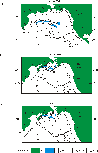
The accretionary structures of Karaginsky Island and, possibly, of East Kamchatka may have started to form in EarlyñMiddle Eocene time by tectonic juxtaposition of the ophiolitic and Late CretaceousñPaleocene island-arc units, the latter being devoid of ophiolitoclastics [Kravchenko-Berezhnoy and Nazimova, 1991]. Prior to that time, the East Kamchatka and Olyutorsky island arcs, whose remnants are found in the accretionary prism, migrated from latitudes of about 40∞ñ55∞ N in a roughly N to NNW direction [Kovalenko, 1992; Chekhovich et al., 1990; Engebretson et al., 1985] together with the Kula plate, the Benioff zone beneath these arcs probably plunging to the south [Kovalenko, 1992; Chekhovich et al., 1990; Kravchenko-Berezhnoy, 1989] (Fig. 10a). The fact that the island-arc sequences show distinct deformation ages in South Koryakia (Miocene) [Chekhovich et al., 1990] and East Kamchatka (Eocene) [Zinkevich and Tsukanov, 1992] provides grounds to believe that the drifting arcs were segmented by transform faults, resulting segments colliding with the continental margin at different times. A transform boundary may have separated the Bowers block, now occurring to the east of the Olyutorsky island arc (Fig. 2).
1, plate boundaries (a, subduction zones; b, transform faults; c, spreading ridges); 2, continents; 3, terranes; 4, spreading zones; 5, ancient plate boundaries; 6, fold-and-thrust belts. Arrows indicate direction of plate motion. EU = Eurasia, NA = North America, PAC = Pacific plate, KU = Kula plate, FA = Farallon plate; terranes: Ka = Kamchatka, Ol = Olyutorsky, Bo = Bowers, Um = Umnak.
The NW-directed subduction at the Karaginsky accretionary prism (marked by the arc-related volcanicñterrigenous complex) devoid of strike-slip component might have been due to either sea-floor spreading in the Komandorsky Basin (Fig. 10b) (as suggested by the presence of MORB-like tholeiites in the flysch of Karaginsky Island and of Kumroch Range in Kamchatka) or to underthrusting of one of the Pacific plates (Fig. 10c). The latter option stipuilates that the Komandorsky shear was nonexistent, and the transform fault that separated the Olyutorsky island arc and the Bowers block evolved into a transtensional structure (Fig. 10c). In this situation, sea-floor spreading supposedly taking place in this structure would account for the MORB-like basalts present in the Eocene flysch on Karaginsky Island [Kravchenko-Berezhnoy et al., 1990] and, possibly, in the Kumroch Range [Tsukanov and Fedorchuk, 1991].
At 42 Ma, the Komandorsky shear was incepted [Engebretson et al., 1985]. Thenceforth, the development of the Karaginsky accretionary prism may have been related only with backarc spreading in the Komandorsky Basin, which is believed to continue still. Prior to the second deformation (which is recorded paleomagnetically), the volcanicñterrigenous and flysch sequences dipped steeply (50∞ñ80∞) to the SSE; this dip might have been acquired through the Late Eocene stage of inception of the accretionary prism. The subsequent tilting of the volcanicñterrigenous and flysch complexes may have occurred in post-Early Oligocene time (30 Ma; the upper age limit for the flysch complex) but most likely predated the overlapping Lower Miocene molasse complex. This tilting must have been related with the late stage of back-arc spreading in the Komandorsky Basin.
CONCLUSIONS
The NRM of rocks on Karaginsky Island yields both prefolding (close to the original) and postfolding components.
Vectors of the prefolding NRM components suggest that the MaastrichtianñPaleocene island-arc sequences of Karaginsky Island (volcanicñterrigenous complex) were laid down at latitudes of about 40∞ ñ55∞ N and originally did not form part of either Eurasia (F = 19, D F = 6.5) or North America (F = 17, D F = 4.4).
The studied blocks rotated slightly (by 28∞ ± 4.4∞ ) in a counterclockwise sense in the horizontal relative to the poleward direction, insignificantly (R = - 15, D R = 40 [Beck, 1980; Demarest, 1983; Westphal et al., 1986]) relative Eurasia, and by 44∞ ± 17∞ (R = 44, D R = 17 [Beck, 1980; Demarest, 1983; Westphal et al., 1986]) in a counterclockwise sense with respect to North America. This implies that the Karaginsky accretionary prism arose without any significant strike-slip motions, and plate convergence at this prism must have been nearly head-on.
Similar formative latitudes and senses of rotation obtained from coeval deposits in the northeastern Olyutorsky zone [Kovalenko, 1992a; Kovalenko, 1992b; Kovalenko, 1996] and in East Kamchatka [Levashova et al., in press] suggest that the Karaginsky MaastrichtianñPaleocene island-arc sequence originally formed part of the Olyutorsky island arc of South Koryakia.
Analysis of secondary NRM components reveals that the Karaginsky structure in its development experienced at least two stages of deformation. It may have been during the first stage (possibly, Late Eocene) that the sequences were tilted 50∞ ñ80∞ to the SSW, and during the second stage (Late Oligocene?) that they were tilted by 45∞ ñ65∞ in WNW to NW directions, which coincide with the NW vergence of the present-day structure of Karaginsky Island.
ACKNOWLEDGMENTS
We are grateful to N.A. Bogdanov, S.D. Sokolov, and V.D. Chekhovich for fruitful discussion. This work was supported by the Russian Foundation for Fundamental Research, project nos. 97-05-64609 and 97-05-64610.
REFERENCES CITED
1. Beck, M.E., Jr., Paleomagnetic Record of Plate-Margin Tectonic Processes along the Western Edge of North America, J. Geophys. Res., 1980, vol. 85, pp. 7115ñ7131.
2. Bogdanov, N.A., Chekhovich, V.D., Sukhov, A.N., and Vishnevskaya, V.S., Tectonics of Olyutorsky Zone, in Ocherki tektoniki Koryakskogo nagoríya (Essays on Tectonics of Koryak Highland), Moscow: Nauka, 1982.
3. Chekhovich, V.D., Bogdanov, N.A., Kravchenko-Berezhnoy, I.R., Averina, G.Yu., and Tielman, S.M., Geologiya zapadnoi chasti Beringovomoríya (Geology of the Eastern Bering Sea Region), Moscow: Nauka, 1990.
4. Demarest, H.H., Jr., Error Analysis for the Determination of Tectonic Rotation from Paleomagnetic Data, J. Geophys. Res., 1983, vol. 88, pp. 4121ñ4328.
5. Engebretson, D.S., Cox, A., and Gordon, R.G., Relative Motions between Oceanic and Continental Plates in the Pacific Basin, Geol. Soc. Am. Spec. Pap., 1985, 206.
6. Khramov, A.N., Goncharov, G.I., Komissarova, R.A., et al., in Paleomagnitologiya (Paleomagnetology), Leningrad: Nedra, 1982, pp. 80ñ102.
7. Kirschvink, J.L., The Least-Squares Line and Plane and the Analysis of Paleomagnetic Data, Geophys. J. R. Astron. Soc., 1980, vol. 62, pp. 699ñ718.
8. Kovalenko, D.V., Paleomagnetism of Paleogene Complexes of Ilpinskii Peninsula, Geotektonika, 1992, no. 5, pp. 78ñ95.
9. Kovalenko, D.V., Geologic Interpretation of Paleomagnetic Data for Late Cretaceous and Paleogene Complexes of Olyutorsky Zone, Abstract of Cand. Sci. (Geol.ñMiner.) Dissertation, Moscow: Inst. Lithosphere, 1992, p. 21.
10. Kovalenko, D.V., Paleomagnetism of the Central Part of the Olyutorsky Range, Geotektonika, 1996, no. 6, pp. 64ñ78.
11. Kravchenko-Berezhnoy, I.R. and Nazimova, Yu. V., The Cretaceous Ophiolite of Karaginsky Island (the Western Bering Sea), Ofioliti, 1991, 16 (2), pp. 79ñ110.
13. Kravchenko-Berezhnoy, I.R., Geologic Setting of Magmatic Complexes in the Western Rim of the Komandorsky Basin, Abstract of Cand. Sci. (Geol.ñMiner.) Dissertation, Moscow: Inst. Lithosphere, 1989, p. 20.
14. Kravchenko-Berezhnoy, I.R., Chamov, N.P., and Shcherbinina, E.A., MORB-like Tholeiites in a Late Eocene Turbidite Sequence on Karaginsky Island (the Western Bering Sea), Ofioliti, 1990, 15 (2), pp. 231ñ250.
15. Levashova, N.M., Bazhenov, M.L., and Shapiro, M.N., Late Cretaceous Paleomagnetism of the East Range Island-Arc Complex, Kamchatka: Implications for Terrane Movements and Kinematics of the North-West Pacific, Tectonophysics, in press.
16. Lonsdale, P., Paleogene History of the Kula Plate: Offshore Evidence and Onshore Implications, Geol. Soc. Am. Bull., 1988, vol. 100, pp. 733ñ754.
17. Shapiro, M.N. and Petrina, N.K., New Data on the Geologic Structure of Karaginsky Island, Tikhookean. Geol., 1985, no. 1, pp. 27ñ33.
18. Tsukanov, N.V. and Fedorchuk, A.V., Oceanic Complexes in the Structure of the Eastern Kumroch Range (Kamchatka), Dokl. Akad. Nauk, 1991, vol. 307, no. 4, pp. 943ñ948.
19. Westphal, M., Bazhenov, M.L., Lauer, J.P., et al., Paleomagnetic Implications of the Evolution of the Tethys Belt from the Atlantic Ocean to Pamirs since the Triassic, Tectonophysics, 2986, vol. 123, pp. 37ñ82.
20. Zijderveld, J.D.A., Demagnetization in Rocks: Analysis of Results, Methods in Paleomgnetism, Collinson et al., Eds., New York: Elsevier, 1967, pp. 254ñ286.
21. Zinkevich, V.P. and Tsukanov, N.V., Formation of Accretionary Structure
of East Kamchatka in Late MesozoicñEarly Cenozoic Time, Geotektonika,
1992, no. 4, pp. 97ñ112.