Accretion tectonics and geodynamics of Kamchatka-Sakhalin region
Zinkevich V.P. and Rikhter A.V.
Geological institute of Russian Academy of Sciences, Moscow, 109017, Russia, tel: (095) 3135169, Fax: (095)2318106, E-mail: zin@ginran.msk.su
Tsukanov N.V.
Shirshov Institute of Oceanology of Russian Academy of Sciences, Moscow, 117218, Russia, tel: (095) 1246563, Fax: (095) 1244942, E-mail baranov@sio.rssi.ru
The dredged samples from outcrops of pre-Cenozoic basement showed the similarity with rocks of neighboring onshore areas. These data also as geophysical materials allow to suppose that tectonic structure of the Sea of Okhotsk bottom, also, has partly accretionary origin.
The structural mode of the arrangement of above terranes indicates long discrete process of continental margin generation. The ancient stages of this process are marked in Sakhalin where very intensive tectonic movements took place in Campanian and Maastrichtian time. The tectonic framework of Sakhalin turned into collage of different terranes in the end of Cretaceous - very beginning of Paleogene. In Kamchatka, problematic Campanian, Early Paleogene (?), very intensive Middle Eocene and Late Miocene episodes of accretion and continental growth are determined. Cenozoic history of Sakhalin connected with tectonic evolution of Sea of Okhotsk and Japan sea, but the history of Kamchatka - with the subduction of the Pacific plates.
Available seismic and geologic data on age and composition of the sedimentary cover of Okhotsk plate don’t supply reliable correlation between main tectonic events in offshore and onshore regions. The basement of the Sea of Okhotsk bottom is unconformably covered by Cenozoic sedimentary cover composed of Lower Paleogene, Paleogene-Miocene and Pliocene-Quaternary sequences the dating of which is based on the general correlation’s with onshore areas.
There is the correlation between accretion episodes and rifting processes in Sea of Okhotsk region also as reorganizations of movements of Pacific ocean plates.
Introduction
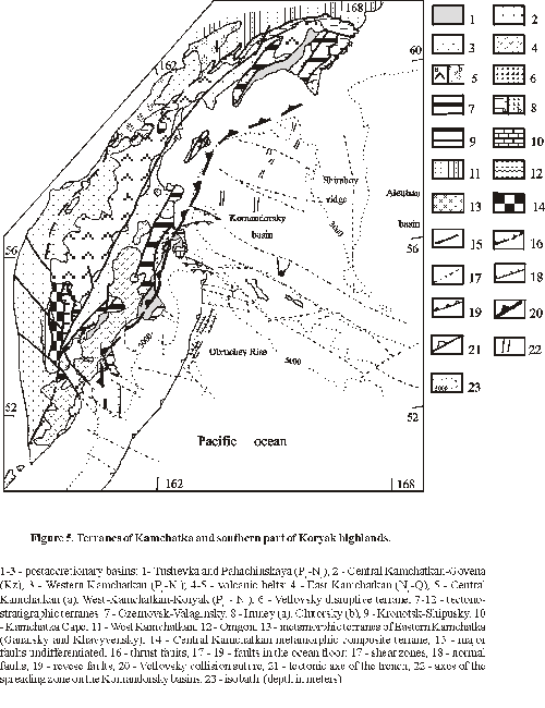
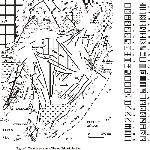
The Sea of Okhotsk region (Figure 1) includes, besides marine basin, bordering land area, because the most part of tectonic units of this sea frame is traced to shelf. The marine basin is bounded by the Kurile island arc to the south, by Kamchatka to the east, by the Asian continental margin to the north and northwest and Sakhalin and Hokkaido to the west. This basin has very complex structure and consists of crust blocks of different types: typically oceanic (South Okhotsk Basin), suboceanic (Derugin Deep) and continental (shelf areas). The mosaic pattern of these blocks results from the junction in this region of tectonic units of different age and origin. The Kurile island arc intersects the Sakhalin-Hokkaido accretionary belt at almost right angle. The continuation of tectonic units of Sakhalin to the north is uncertain. The Okhotsk-Chukotsk volcanic belt borders this region in the north where it overlaps a basement consisting from different tectonic units (Okhotsk and Taigonos massifs of Precambrian and younger rocks, Verkhoyansk folded belt, Uda-Murgal volcanic belt). Tectonic units of Kamchatka are continued to north in Koryak highlands and occupy large part of neighboring shelf.
As a whole, the trends of main structures of Okhotsk frame follow the outline of Sea of Okhotsk that was used during long time to establish boundaries of ancient Okhotsk massif. It was believed that this massif occupies entire part of Sea of Okhotsk [Kropotkin and Shakhvarstova, 1965; Parfenov, 1984; Natal’in and For, 1991]. Markov et al. [1967] shown that entire part of the Sea of Okhotsk bottom consists of same rocks as ones in onshore areas. The results of dredging from the bottom [Geodekyan, et al., 1976] supported this point of view about the absence of Okhotsk massif in the center of Sea of Okhotsk.
Sea of Okhotsk region has been described by many authors [Markov et al., 1967; Raznitsyn, 1982; Gnibidenko, 1982; Belousov and Udintsev, 1981; Savostin et al., 1983; Nokleberg et al., 1994; Watson and Fujita, 1985, and by many others]. Geophysical research results have been presented by [Kosminskaya et al.,1964; Kochergin et al., 1975, and by many others]. During the last decade, the understanding of the geological framework and evolution of Kamchatka and Sakhalin and their vast continental shelf has greatly advanced as a result of research carried out by academic and government sponsored institutions and national geological surveys.
New geological materials on the composition of pre-Cenozoic complexes of Kamchatka [Zinkevich and Tsukanov, 1993] and Sakhalin [Rikhter, 1986] has demonstrated that both regions are composed of a mosaic of terranes accreted to Siberia at various times mainly in Late Cretaceous and Early-Middle Cenozoic. These terranes (fragments of island arc chains, back-arc basins, and oceanic plateaus) experienced a complex history of subduction, collision and strike-slip tectonics and played main role in the producing of the modern tectonic structure of the region.
The evidence of the accretionary framework of the periphery of Okhotsk plate gives us a possibility to analyze the tectonic history of Sea of Okhotsk region from the point of view of accretionary tectonics. The specific aims of this paper are to (1) outline the new materials on tectonics of Kamchatka and Sakhalin; (2) discuss tectonic style of offshore and onshore parts of Sea of Okhotsk region; (3) present possible model for tectonic evolution of the region.
Regional Geologic Framework of Western Sea of Okhotsk Region
The frame of the Sea of Okhotsk region consists of structural elements of different ages and origin (Figure 1).
Uda-Murgal volcanic belt consists mainly of Upper Jurassic to Lower Cretaceous (Hauterivian), chiefly basaltic to andesitic, rarely dacitic volcanic rocks that extend from western coast of Sea of Okhotsk to Taigonos peninsula and far to north, to Koryak highlands. Parfenov [1984] gives the evidence of more ancient (Triassic, possibly Permian) age of southern part of this belt. The volcanics are associated with shallow water sediments of various facies. Despite the discontinuous distribution of volcanic rocks in the Uda-Murgal belt, the calc-alkaline composition of volcanic rocks indicates a genetic link with subduction of an oceanic crust. Parfenov [1984] showed that Uda-Murgal volcanic belt was related with Benioff zone dipped at approximately 65o-70o to the northwest.
Uda-Murgal volcanic belt is interpreted to have formed as volcanic arc within Eurasian continental margin.
Okhotsk-Chukotsk volcanic belt consists predominantly of subaerial calc-alkalic andesitic-basalt to ignimbritic and rhyolitic flows, tuff, agglomerate, and breccia, with minor amount of basalts and volcaniclastic rocks intruded by gabbro and granitoid intrusions of Cretaceous age. The volcanics erupted during 25 Ma from mid-Albian to early Senonian [Belyi, 1994]. Belyi [1994] divides this belt along its continuation at three parts. It depends, in his opinion, of the heterogeneity of its basement because this belt lies on the different tectonic units. He distinguishes, also, outer and inner zones. The former is superimposed on Mesozoides and pre-Riphean continental block. The latter overlies the structures of Uda-Murgal volcanic belt. Highly aluminous basalt, andesite, diorite, tonalite, and granodiorite prevail in the inner zone; andesite, rhyolite, granodiorite, quartz monzonite, and granite - in the outer one.
Okhotsk massif, roughly triangular in outlines is exposed in northern part of region among terrigenous complexes of Mesozoides. It is confined by complexly formed fault zones to the north-west and north-east [Chikov, 1970]. The southern boundary of this massif is uncertain.
The massif consists of the Archean crystalline basement and Proterozoic-Paleozoic and Mesozoic sedimentary cover. The basement rocks are composed of amphibolite-facies gneiss, schist, and amphibolite, rarely by calciphyre, marble, and quartzite. The sedimentary cover unconformably overlying crystalline complex consists of Proterozoic quartzite, slate, and limestone; Late Cambrian limestone, sandstone, and slate; Lower Ordovician limestone, dolomites, carbonatous sandstone; Silurian limestone and sandstone and Middle-Upper Devonian tuffaceous sandstone, slate, limestone, gravelstone, alternated andesite, rhyolite, and tuff. Mesozoic rocks represented by Upper Triassic and Lower-Middle Jurassic terrigenous formations and Upper Jurassic and Neocomian volcanic and coarse-sedimentary complexes. The widespread late Lower Cretaceous and Upper Cretaceous rocks represented by mainly siliceous and intermediate, rarely mafic volcanics.
Balygichansky massif is situated in the north-eastern part of the region. Its existence is proposed because terrigenous rocks of Verkhoyansk Complex very gently lie in this area [Tilman and Bogdanov, 1992]. The outcrops of ancient rocks similar to those of Okhotsk and Omolon massifs are absent.
Omolon massif. It is exposed only little part of this continental block in this area. The massif consists of Archean crystalline basement overlapped by Riphean and Ordovician - Jurassic carbonate-terrigenous, volcanic-sedimentary and terrigenous sequences [Terekhov, 1979]. Archean (or Lower-Middle Proterozoic) rocks are represented by gneiss and plagiogneiss, crystalline schist, quartzite, and plagiogneiss, minor amphibolite, eclogite, migmatite, and pegmatoid granite. Upper Proterozoic sequence is made up of carbonate-terrigenous rocks (quartzite, quartz sandstone, and shale). Ordovician rocks are composed of limestone, carbonatous siltstone, dolomite, minor siltstone, sandstone. The sequence represented by subaerial volcanics (rhyolite and dacite) of Devonian age unconformably rest on underlying complexes.
Devonian-Carboniferous rocks are represented by arcose and polymict sandstone, gravelstone, and conglomerate, minor limestone, and carbonate sandstone. Permian sequence consists of conglomerate, gravelstone, sandstone, mudstone, slate, minor argillite, limestone, siliceous argillite. Triassic sequences are represented by terrigenous rocks (siltstone, mudstone, argillite, minor limestone). Latest Triassic sequence includes also conglomerate and gravelstone. Lagoon-continental Jurassic sequence consists of sandstone, gravelstone, siltstone, minor conglomerate, tuff, tuffite. Lower Cretaceous sequence is represented by continental sedimentary rocks.
Paleozoic-Mesozoic rocks characterize a gradual subsidence with accumulation of thick shelf and terrace wedge sequences.
Mesozoides are composed of Verchoyansk Complex rocks including thick Carboniferous, Permian, Triassic and Jurassic terrigenous sequences. The marine terrigenous rocks (siltstone, mudstone, sandstone) are more widespread, but continental, lagoon and shallow-marine sandstone occur near large outcrops of ancient continental basement.
The rocks of Verchoyansk complex were accumulated within passive continental margin environment at a broad shelf submerged to north-eastward direction. The general change from carbonatous to terrigenous sedimentation occurred between Middle and Late Paleozoic possibly is connected with a change of climatic environment during the displacement of the region from equatorial latitudes to northern ones [Parfenov, 1984].
Sikhote-Alin and Mongol-Okhotsk Accretionary Systems.
Western part of the region, to south of Siberian craton, includes Mongol-Okhotsk and Sikhote-Alin accretionary systems. The former was connected with closure of Mongol-Okhotsk paleo-ocean and, later, with collision of Siberian craton and Burein massif in Middle-Late Jurassic. Galam and Ulban terranes is exposed here as only little part of this system (Figure 1, figure 2). The latter is usually interpreted as a packet of Mesozoic accretionary complexes formed near eastern margin of Asia during subduction of Pacific plates in Late Mesozoic. It consists of Gorinsky, Nizhne-Amur, Sergeevsky, Hungarian, Kemsky, Samarsky and Zhuravlesky terranes (Khanchuk, 1993) emplacing at their present position by left-lateral strike-slip faults. We characterize these terranes very briefly after Khanchuk [1993] and Parfenov, [1984] because the description of these tectonic units is necessary only for general understanding of the aims of this paper.
Galam terrane consists of Cambrian, Silurian-Middle Devonian, Middle Devonian-Lower Carboniferous, and Upper Permian complexes with uncertain relationships [Parfenov, 1984].
Cambrian complex is composed from jasper, chert, graywacke, tholeiitic and alkaline basalts, blocks of reef limestone and dolomite. Silurian-Middle Devonian complex is represented by deep-water siliceous-terrigenous rocks with mafic volcanics and shallow-marine arcose and graywacke sandstone. There are of limestone olistolites Early Ordovician, Cambrian and Late pre-Cambrian ages. Middle Devonian-Lower Carboniferous complex consists of flyschoid sequences, minor breccia, gravelstone, conglomerate, siliceous shale, basalt. Upper Permian sequence forms little tectonic blocks in tectonic zones. It is composed of continental and shallow- marine conglomerate and sandstone with interlayers of siliceous and carbonatous rocks.
Mesozoic sequences unconformably rest on Paleozoic rocks. They include Upper Triassic-Jurassic shallow-marine coarse-terrigenous rocks which are overlain without angular unconformity by Neocomian continental terrigenous rocks with interlayers of silicic lava and tuff. The source of volcanic material was likely Uda-Murgal volcanic arc [Parfenov, 1984].
Ulban terrane is situated to south of the Siberian platform. Its boundaries with Galam and Gorinsky terranes are thrust faults. Ulban terrane is composed of graywacke, flysch packets, chert, and minor basalt with general thickness up to 10000 m. [Parfenov, 1984]. The rocks are intensively deformed in different folds and are broken by faults, including thrust faults. Jurassic rocks of this terrane deposited as turbidites in deep marine environment near continental slope.
Gorinsky terrane has a melange-type structure consisting of sheets and blocks composed of Triassic and Jurassic chert, basalt, gabbro, limestone of Late Carboniferous, Permian, and Late Triassic ages, metamorphic schist, and Titonian-Valanginian sandstone and siltstone. The matrix is composed of sandstone and siltstone of Early Hauterivian - Early Barremian age.
Nizhne-Amursky terrane consists of tectonic sheets composed of Upper Jurassic to Lower Cretaceous chert and limestone overlaying on oceanic basalt. Upper parts of these sheets are composed by Aptian-Albian turbidites [Khanchuk, 1993].
Samarkinsky terrane in central Sikhote-Aline is in fault contact with Hungarian and Nizhne-Amursk terranes. It composed of the olistostrome complex that looks as a gigantic sedimentary melange containing allochthonous blocks. These blocks consist of: 1) fragments of ophiolite, which basalts of are overlain by Upper Devonian to Lower Permian chert and Lower Carboniferous to Lower Permian limestone; 2) basalt overlain by Upper Permian chert; 3) Middle to Upper Triassic chert, sometimes in association with basalt; 4) Lower Jurassic siliceous-terrigenous sediments; 5) Upper Permian and Triassic-Jurassic sandstone; 6) pycrite and basalt of uncertain age; 7) greenschist and amphibolite facies metamorphic rocks formed from ophiolite; 8) greenschist and glaucophane schist formed from meta-pelites and high-titanium meta-basites (in upper part of Samarsky terrane and in the basement of Sergeevsky terrane). Among turbidite matrix of Callovian-Early Cretaceous age, there are also extended at tens kilometers tectonic sheets of more ancient chert that are not connected with olistosrome. The turbidite and olistostrome sequences are unconformably overlain by coarse-clastic coal-bearing sedimentary strata of Late Valanginian - Albian age.
Samarsky terrane is considered as a fragment of the Middle Jurassic-Berriasian accretionary prism [Khanchuk, 1993].
Hungarian terrane consists of tectonic sheets composed of Middle-Upper Triassic chert and pelagic limestone with minor intraplate basalt also as of Lower to Middle Jurassic siliceous and terrigenous rocks and turbidites of Late Jurassic-Berriasian age.
Zhuravlevsky terrane, in central and southern Sikhote-Aline, is made up by complexly deformed Early Cretaceous (from Valanginian to Albian) turbidite. It is very thick (up to 6000 m) flyshoid sequence containing shallow-marine fauna of Barremian-Early Senonian age [Parfenov, 1984]. To the east, sequence includes tuff and andesite.
The rocks of Zhuravlevsky terrane are interpreted as sediments of turbidite basin [Khanchuk, 1993].
Kemsky terrane is exposed in eastern part of Sikhote-Alin (Figure 2) among flat-laying volcanics of East Sikhote-Alin belt. It is composed of complexly deformed shallow-water marine and continental volcanics and sedimentary rocks (up to a few kilometers thickness). Volcanics include andesite, andesite-basalt, basalt, minor rhyolite). These rocks are interpreted as Aptian-Albian island arc [Khanchuk, 1993; Melankholina,, 1988;].
Koryak Accretionary System
Discussed region covers only little part of Koryak accretionary system exposed in the Taigonos peninsula and in south-west Koryak highlands (Figure 1). In general, tectonic framework of this system consists of accreted of Mesozoic margin terranes of island arc and oceanic origin.
In Taigonos peninsula, the ancient craton complex (from Archean to Riphean - Lower Paleozoic) is exposed in its northern part [Nekrasov, 1976]. To north, ancient rocks of Taigonos continental block contact along thrust fault with folded volcaniclastic and sedimentary assemblages of Early Paleozoic to Jurassic age. The volcanics and volcanoclastic rocks of Uda-Murgal volcanic belt are exposed in narrow north-east trending zone in southern Taigonos peninsula.
Two small specific complexes are exposed in south-eastern part of this peninsula [Chekhov, 1994]. Povorotny Cape Complex includes the imbricated ophiolite assemblage from Triassic to Jurassic age, same as Kuyul ophiolite in Koryak highlands. It composed of tectonic sheets consisting from serpentinite melange, eclogite, amphibolite, greenschist, chert, and pillowed basalt. Another complex consists of thick mafic and ultramafic rocks and diorites overlying folded greenschist and blueschist complex. Also, there are phyllites containing Middle Ordovician conodonts. All complexes of Taigonos peninsula underwent intense deformations as well as metamorphism related to the formation of the Uda-Murgal volcanic belt.
Sakhalin-Hokkaido Accretionary System
There are apparently similarities between the geology of Sakhalin and Hokkaido indicating that the main tectonic units of both islands constitute uniform accretionary system. Their comparison was held not so far ago [Kimura et al., 1983; Dobretsov et al., 1994].
Sakhalin Island consists of the Western terrane, Aniva-Central-Sakhalinsky and Eastern composite terranes (Figure 3, figure 4).
Western terrane consists of Lower Cretaceous - Miocene formations (thickness about 10 km). It is bounded from east by the system of right strike-slip faults and thrusts. Lower Cretaceous sequence (from Berriasian - to Albian, thickness 120 m) is composed of radiolarite, chert, siliceous argillite interbedded with alkaline basalt. Siliceous rocks were deposited in oceanic environment, like as modern radiolarian muds and deep-sea red clays. The Lower Cretaceous rocks are concordantly overlain by Upper Cretaceous (Albian-Turonian) deep-sea terrigenous turbidites (thickness 3500 m), and more shallow-marine Late Cretaceous and Cenozoic terrigenous rocks. Upper Cretaceous and Cenozoic sediments, containing interlayers of andesite and silicic tuff, probably were accumulated near continental East-Sikhote-Alinsky volcano-plutonic marginal belt.
Aniva-Central-Sakhalinsky composite terrane consists of Central - Sakhalinsky, Mereisky, Gomonsky, Anivsky, Langeriysky, and Susunaysky terranes.
Central - Sakhalinsky terrane in the central Sakhalin Island is overthrusted by Langeriysky or Gomonsky terranes from east and by Western terrane from the west. It made up of Upper Permian limestone and mafic volcanics, of Triassic to Lower Cretaceous volcanics and chert, and Upper Cretaceous terrigenous formations. Upper Permian basalts and reef limestones are small boulders in Albian-Cenomanian sequence, while Triassic-Lower Cretaceous rocks form homogeneous sequences. Triassic part of the sequence consists of oceanic tholeiitic basalt, minor alkaline basalts, and hyaloclastite with interbeds of radiolarite; Lower Jurassic-Albian sequence composed of chert and radiolarite. Cherts and volcanics are unconformably overlain by Albian-Cenomanian conglomerate-breccia and Upper Cretaceous argillite and sandstone.
Up to Late Cretaceous, Central-Sakhalinsky terrane was likely a part of abyssal oceanic plate which was deformed in Albian-Cenomanian time. In Late Cretaceous, it has been a part of the deep-sea structural rise (terrace-similar scarp) between a trough, to east, and marginal basin, to west.
Mereisky terrane exposed in Southern Sakhalin is similar in lithology and origin to Central-Sakhalinsky terrane. It consists of Lower Cretaceous (?) basalt, overlain with angular unconformity by Albian- Cenomanian conglomerate and graywacke sandstone. Upper Cretaceous sequence is composed of turbidites.
Gomonsky terrane exposed near western foothills of the East-Sakhalin mountains consists of Albian-Cenomanian olistostrome, including blocks of serpentinite, gabbro, amphibolite of uncertain age, Upper Paleozoic chert, basalt, and reef limestone; large blocks of Triassic-Lower Cretaceous radiolarite, chert, various basalts and Late Jurassic reef limestone as well as parts of sequences of intermitting radiolarite and micritic limestone. These blocks are fragments of abyssal oceanic plate, guyots, volcanic plateau and seamounts. Olistostrome matrix consists of siliceous argillite. Albian-Cenomanian complex is overlain by Upper Cretaceous siliceous argillite and turbidite. These deposits are interpreted as sediments of a trough or a deep-sea terrace near the eastern slope of the Central-Sakhalinsky scarp.
Anivsky terrane in Southern Sakhalin composed of Permian-Upper Cretaceous formations is similar to Gomonsky terrane. Permian chert and reef limestone, as well as Triassic-Lower Cretaceous basalt, chert, jasper, radiolarite, and limestone are included as blocks in olistostrome of Albian-Cenomanian age. Also, there are blocks of basalt and reef limestone containing shallow-water fauna of Permian, Late Triassic, and Late Jurassic ages in this olistostrome. The basalts have tholeiitic and alkaline affinities, typical to basalt of oceanic volcanic rises and islands. In the west, in the thrust fault zone, there is the tectonic block, consisting from Middle Triassic to Cenomanian chert and radiolarite. Triassic-Aptian rocks of this block consist of radiolarite. Albian-Cenomanian sequence is composed of chert and siliciclastic rocks with impurity of the volcaniclastic material. Likely, this block is a fragment of an oceanic plate. Albian-Cenomanian olistostrome is overlain by Upper Cretaceous terrigenous turbidites. The top of sequence consists of tuff-terrigenous rocks and silicic tuff.
Langeriysky metamorphic terrane in western foothills of East-Sakhalin mountains consists of the packet of tectonic nappes, composed of Jurassic-Lower Cretaceous volcanic formations with rare interbeds of chert and Upper Cretaceous laminite. Volcanic and sedimentary rocks have suffered from metamorphism from prehnite-pumpellyite up to low-grade biotite-bearing greenschist facies (K/Ar dates of 71-58 Ma). The metamorphism of the rocks increases downward in the structurally lower part of this terrane. Protolite of the Langeriysky terrane is similar to unmetamorphosed formations of the neighboring terranes. The serpentinite melange in the base of the packet of tectonic nappes contains blocks of ultramafics, various amphibolites, amphibol-and quartz-mica schists of blueschist facies (K/Ar dates of 92 Ma).
Jurassic-Cretaceous formation of this terrane is interpreted to have been part of an oceanic plate. The Upper Cretaceous sequences differ from more western terranes by the absence of sandstone and wide occurrence of siliceous laminites formed in deep-sea conditions, typical to removed (or isolated from source of a terrigenous material) marginal parts of the Late Cretaceous oceanic plate.
Susunaysky metamorphic terrane in southern Sakhalin consists of the packet of tectonic nappes. Lower parts of sequences in these tectonic sheets are mainly composed of silicic and volcanic rocks and upper parts - of terrigenous ones. Early Triassic - Early Cretaceous age of these rocks are determined by conodonts and radiolarians [Rikhter,1986]. The volcanics are tholeiitic, subalkaline, and alkaline basalts, typical to abyssal plates and ocean islands. Overlying formations composed of interbedded siliceous and terrigenous rocks that grade upward into flysch with interlayers of tuff and sandstone with carbonate concretions, containing of Late Cretaceous-Paleogene (?) radiolarians. The rocks are metamorphosed in greenschist facies (K/Ar date of 60-55 Ma). In foots of tectonic nappes, there is serpentinite melange with blocks of ophiolite, eclogite (133 Ma), amphibolite (206, 178 Ma), and glaucophane schist (90-95 Ma).
Triassic-Lower Cretaceous formations are interpreted as a part of ancient oceanic plate, whereas Upper Cretaceous formations have been terrigenous sediments of the marginal basin near continental slope.
Eastern composite terrane consists of Nabilsky, Kotikovsky, Rymniksky, West-Schmidtovsky, Elizavetinsky and East-Schmidtovsky terranes (Figure 3, figure 4).
Nabilsky terrane in East-Sakhalin mountains consists of the packet of tectonic nappes composed of Lower Jurassic-Maastrichtian chert, volcanics, and terrigenous rocks. It is bounded to west by a system of Later Cretaceous-Paleocene thrusts and Pliocene strike-slip faults.
Early Jurassic-Albian part of the sequence consists of radiolarite interbedded with rare basalt and micritic limestone. These rocks are interpreted to have been an abyssal part of an oceanic plate.
In the top of terrigenous Albian-Santonian sequence, there is olistostrome containing blocks of Upper Cretaceous sandstone, siltstone, tuff, and silicic and intermediate effusives among argillite and siliceous rocks. Campanian rocks include tuffaceous siliceous argillite, andesite, trachyandesite, and basalt of island-arc origin. Maastrichtian sequence consists of clastic rocks with regressive type of sedimentation. Upper Cretaceous formations are interpreted as sediments of an ocean basin near volcanic island arc.
Kotikovsky terrane consists of marine and subaerial volcanic and sedimentary formations of Santonian-Danian age.
Santonian-Lower Campanian part of the sequence is composed of tuff interbedded with conglomerate containing pebbles of effusives, tuff, jasper, and limestone. Campanian rocks include tuff and tuffaceous sandstone with interbeds of marine and subaerial lava flows. Volcanic rocks have calc-alkaline, subalkaline and alkaline affinities, typical to island arcs [Grannik, 1978]. Maastrichtian-Danian (?) sequence is composed of shallow-marine terrigenous deposits with coal and deep-sea flysch which contains numerous carbonate concretions and lenses of sandstone and conglomerate. Upper Cretaceous formations of this terrane were probably accumulated in East-Sakhalinsky island arc and neighboring shallow-marine fore-arc basin [Rozhdestvensky,1986; Grannik, 1978].
Rymniksky terrane is composed of Coniacian (?) - Maastrichtian formations. Coniacian (?) - Santonian siliceous argillite, jasper, siliceous tuffite, and ashy tuff are overlain by Campanian tuff and lava flows (poor-titanium basalt, trachyandesite, and extruded quartz albitophyre and rhyolite) interbedded with jasper and limestone. Maastrichtian sequence is composed of volcanic and terrigenous rocks with olistostrome [Grannik, 1978; Raznitsin, 1982].
Upper Cretaceous formations were probably deposited in a deep-sea back-arc basin near the East-Sakhalinsky island arc.
West-Schmidtovsky terrane in western and central Shmidt peninsula consists of Upper Cretaceous terrigenous and volcanic complexes. The lower part of terrigenous sequence is composed of shallow-marine gravelstone, sandstone, and siltstone, containing interlayers of coal with flora of Coniacian-Early Campanian age. The overlapping sequence is composed of basalt, andesite, trachyandesite, trachyrhyolite, and tuff. Trachyandesite flows yielded radiometric K-Ar dates of 99 - 50 Ma whereas quartz-trachyandesite (extrusion facies) yielded K/Ar date of 52 Ma.
These rocks are interpreted to represent a volcanic complex of the East-Sakhalinsky island arc [Rozhdestvensky,1986], or a part of the East-Sikhote-Alin volcanic belt.
Elizavetinsky terrane overthrusted on the West-Schmidtovsky terrane consists of Cenomanian-Campanian tuffaceous and clastic deposits. Cenomanian part of sequence consists of siltstone with marl concretions and tuffaceous flysch, which is overlapped by Turonian-Campanian terrigenous flysch.
East-Schmidtovsky terrane is composed of a system of tectonic sheets overthrusted on the Elisavetinsky terrane. The sheets consist of ultramafic rocks, gabbro intruded by dikes of diabase, gabbro-plagiogranite of Campanian age (K/Ar date of 87,1 Ma), basalt and spilite with interlayers of chert, containing radiolarians of Albian-Cenomanian and Campanian ages. The basalt contains numerous exotic blocks of chert, jasper, and limestone of Paleozoic, Jurassic and Early Cretaceous ages. The lower parts of tectonic sheets usually turned into serpentinite melange.
Hokkaido Island. Pre-Neogene complexes in Hokkaido are grouped into Oshima- Rebun, Sorachi-Yezo, Hidaka, Tokoro, and Nemuro terranes.
Oshima-Rebun terrane is composed of Upper Paleozoic (?) to Triassic sedimentary strata, Upper Jurassic to Lower Cretaceous volcanics and Early Cretaceous granites. These complexes are covered by Neogene to Quaternary sediments mainly composed of thick pyroclastics [Kiminami and Kontani, 1983]. Both basement and pyroclastic cover rocks are regarded to represent the northern extension of Honshu geologic units.
The Oshima-Rebun terrane is a part of the Jurassic accretionary complex and consists of tectonic nappes. It is composed of Upper Carboniferous-Permian oceanic greenstone and bedded chert and Middle to earliest Upper Jurassic mudstone containing olistolithes of Permian sedimentary rocks and Triassic-Lower Jurassic chert. The upper parts of the sequence are composed mainly of Upper Jurassic sandstone of which the provenance is regarded to be the continent or island arc [Ishiga and Ishiyama, 1987].
In the eastern Oshima-Rebun terrane, there are sequences composed of Triassic-Valanginian oceanic basalt and chert; turbidites, chert, mudstone, andesite, tuff, and basalt of uncertain age covered by Yezo Complex turbidites of Aptian-Maastrichtian age [Okada et al., 1982].
Sorachi-Yezo terrane is composed of the Sorachi and Yezo complexes, ophiolite and serpentinite melange including the Kamuikotan metamorphic complex (Kiminami and Kontani, 1983).
The Sorachi complex represents the upper part of ophiolite sequence. It is composed of Upper Jurassic to Lower Cretaceous oceanic tholeiitic basalt, hyaloclastite, chert, rare limestone, overlain by Lower Cretaceous flysch-like interbedding of chert and tuffite as well as sandstone in the top of the sequence [Kiminami, Kontani, 1983].
The Yezo complex (Aptian to Maastrichtian) conformably, locally to the east - unconformably overlies the Sorachi complex. It is composed of thick turbidite sequence with interbeds of tuff and shallow-marine coarse-grained sediments derived chiefly from the source provenance to the west.
The overlapping Paleogene sequence is composed of nonmarine, in the lower part of sequence, and marine, in the top of sequence, sediments. The Sorachi-Yezo terrane corresponds to the Western terrane of Sakhalin.
In the eastern Sorachi-Yezo terrane, there is Kamuikotan Tectonic Belt including tectonic nappes, composed of metaophiolite underlying serpentinite melange and Kamuikotan metamorphic complex. In the Kamuikotan metamorphic complex, greenschist and blueschist yielded isotopic dates of 110 - 90 Ma and metapelite and diaphtorite - 70-55 Ma. Isotopic ages of metagabbro and amphibolite from tectonic blocks in serpentinite melange range in age from 180-132 Ma.
The Kamuikotan metamorphic Belt extends to Sakhalin as the Susunaysky metamorphic terrane.
Hidaka composite terrane includes the Idonnappu terrane, Main Hidaka terrane, metaophiolitic Poroshiri and Hidaka metamorphic complex.
Idonnappu terrane consists of two tectonic nappes dipping to east. Lower unit is composed of olistostrome-turbidite formation of Aptian-Cenomanian age; upper unit is melange consisting of blocks of tholeiitic and alkalic basalts, red radiolarite, Cretaceous sandstone and Middle Cretaceous shale containing limestone olistolites of Permian, Triassic, and Jurassic ages.
This terrane is similar to Anivsky and Gomonsky terranes of Sakhalin.
The Main Hidaka terrane is composed of different complexes of Santonian- Campanian age. Tomuraushi greenstone complex includes two associations: siltstone with dolerite and ocean tholeiite with hyaloclastite [Miyashita, Katsushima, 1986]. The melange-like Shimokawa Complex is composed of breccias of basalt, dolerite, sandstone, and siltstone in black mudstone of the top of the sequence (olistostrome). Blocks of metagabbro and serpentinite occur near faults.
At the northeastern edge of the Hidaka terrane, there is the olistostrome (formation Kanayama) including olistolithes of Permian to Cretaceous limestone, chert, hyaloclastite, tuffaceous sandstone, and siliceous mudstone. Matrix of Late Campanian-Early Maastrichtian age is composed of siltstone and sandstone interbedded with tuffaceous siltstone [Iwata, Tajika, 1989].
On the south, above formations also as Nakanogava Formation (Tokoro terrane) are intruded by granitoides and are metamorphosed. Metamorphic grade varies from west to east from amphibolite facies to greenschist facies and hornfels (Hidaka metamorphic complex). Migmatite and granites in Hidaka complex yielded radiometric dates of 36-23 Ma. From the west, this metamorphic complex in Middle Miocene - Pliocene time thrusted on the Poroshiri ophiolite composed of olivine-plagioclase cumulates and gabbroides with MORB chemical affinities.
The Hidaka terrane is similar to the upper part of the sequence in the Nabilsky terrane of Sakhalin.
Tokoro terrane is composed of Jurassic-Upper Cretaceous complexes. The lower stratigraphic unit (Nikoro complex) consists of Upper Jurassic-Lower Cretaceous oceanic tholeiitic pillowed and massive basalt, alkaline basalt, hyaloclastite, radiolarite, and limestone overlain by massive sandstone.
The Nakanogava complex (to the east from the Hidaka metamorphic belt), Yubetsu and Soroma complexes (the northern part of the Tokoro terrane) are composed of Santonian- Campanian turbidites, sandstone and mudstone with intercalations of tuff and conglomerate. The terrigenous rocks contain clasts of basaltic to siliceous volcanics. The terrigenous material have been probably derived from a land with active volcanism [Kiminami, Kontani, 1983].
Tokoro terrane corresponds to north-eastern part of the Nabilsky terrane in Sakhalin.
Nemuro terrane is composed of Campanian through Paleocene Nemuro Group unconformably overlain by coal-bearing Oligocene strata and Neogene marine beds with andesitic pyroclastic rocks, being covered by Quaternary volcanics. Nemuro Group, more 3,000 m thick, consists of alkaline pillow lavas with dates of 89-65 Ma in the lower sequence, flysch facies in the middle, and shallow marine, coarse-grained sediment in the top of the sequence [Okada, 1983].
Formations typical to Nemuro terrane extend over several hundreds' kilometers to the east as Lesser Kurile and Vityaz submarine rise representing non-volcanic outer arc of the Kurile arc-trench system. The age and composition of these rocks allow to find likeness to Kronotsk-Shipunsky terrane of Eastern Kamchatka.
Accretionary System of Kamchatka.
A substantial part of Kamchatka is covered by Cenozoic volcanic and sedimentary
formations which mask the identity and relations among older rocks. The effusives
are lumped together into the Western Kamchatkan-Koryak
(P2-N1), Central Kamchatkan
(P3-Q) and East Kamchatkan (N2-Q)
volcanic belts whose age becomes younger toward Pacific ocean. Western
Kamchatkan-Koryak and Central Kamchatkan volcanic belts traced far to the
north into the Koryak highlands, and East Kamchatkan belt is the northern
extension of the volcanic belt of the Kurile-Kamchatka island arc.
In West Kamchatka, Cenozoic clastic deposits overlie Mesozoic formations in an almost continuous cover. In Central Kamchatka, they fill the Central Kamchatka graben, extending northeastward across the entire region from Kamchatka River to Litke Strait. In East Kamchatka, exposures of older rocks have been found among the Cenozoic rocks in uplifted tectonic blocks. Also, very substantial outcrops of the ancient rocks occur under Cenozoic cover in the Tushevsky basin (Figure 6), a long linear structure partly exposed on land and partly covered by Pacific Ocean.
Terranes of Pre-Cenozoic Basement of Kamchatka
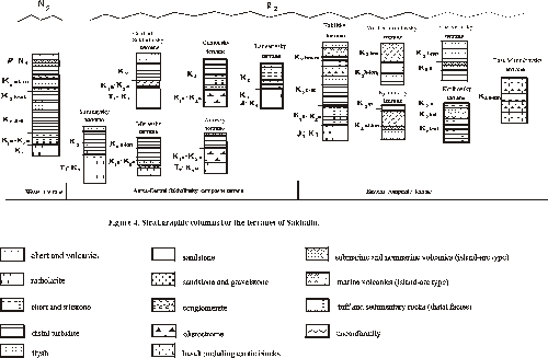
The composition and structure of pre-Cenozoic complexes in Kamchatka enable to distinguish among them different tectonic units (Figure 5, figure 7) and to classify them as tectonostratigraphic (Omgon, West-Kamchatkan, Iruney, Ozernovsko-Valaginsky, Kronotsko-Shipunsky), composite (Kamchatka Cape), disruptive (Vetlovsky) and metamorphic (Central Kamchatkan, Ganalsky and Khavyvensky) terranes [Zinkevich and Tsukanov, 1993] .
Omgon terrane is in westernmost Kamchatka, on the shore of Sea of Okhotsk. A recent study of this region [Bogdanov et al., 1991; Bondarenko and Sokolkov, 1990] showed that it consists of three thrust slices dipping to the southeast. The lower slab consists of basalts with lenses and bands of chert; the middle one, of volcanogenic-sedimentary formation; the upper, of basalts interbedded with chert and limestone containing Middle Jurassic and Late Jurassic-Valanginian radiolarian, and in the top of the section, Late Berriasian-Valanginian Buchia. The rocks of the middle slab are unconformably overlain by latest Lower Cretaceous to Maastrichtian turbidites.
Petrochemical and geological data [Bondarenko and Sokolkov, 1990] show that these volcanic and volcanogenic-sedimentary rocks were formed in the Middle Jurassic - Early Neocomian in an island arc setting. Island arc formations of Omgon terrane have no analogies in neighboring parts of Kamchatka, but they are remarkably similar in age and lithology to formations of southern Koryak accretionary system [Bondarenko and Sokolkov, 1990].
West-Kamchatkan terrane comprises scattered outcrops of Cretaceous terrigenous rocks in Western Kamchatka, traceable northward to the Kamchatka isthmus and then on into Koryak highlands. No complete section is known, due to intensive tectonic reworking and small outcrops area. The information on underlying terranes is sparse or absent. Early Cretaceous (Aptian) to Late Cretaceous age of the clastic formations was determined on the basis of very rare finds of inoceramids [Geologiya...,1964; Sidorchuk and Khanchuk, 1981]. Sandstone, siltstone and mudstone are interbedded in relations pointing to an origin as distal turbidites or, more often, as sediments of contour currents in a deep-sea environment. The coarse-clastic rocks are very rare also as siliceous tuff, chert including pure radiolarite, tholeiitic pillowed basalt, and volcaniclastic rocks [Shapiro et al., 1992]
The intensively deformed clastic deposits of West-Kamchatkan terrane are uniform. No steady tendency toward a change in composition of the sandstones from the south to the north along the West Kamchatka to Koryak highlands is observed [Shapiro et al., 1992]. The central part of Koryak highlands is composed of Cretaceous (Albian to Maastrichtian) terrigenous rocks [Vorogushin, 1992; Kazimirov et al., 1987]. From the northwest to the southeast, the composition of most widespreaded Campanian rocks change from coarse slope sediments to deep marine sediments of debris and contour flows [Kazimirov et al., 1987]. The lithology of Cretaceous rocks suggests that their source was a Koryak continental margin that provided abundant clastic material to the continental shelf, slope, and to the neighboring part of the marginal basin.
Iruney terrane consists of folded packet of tectonic nappes thrusted westward on the West-Kamchatkan and Central Kamchatkan terranes. To the north, the most part of Iruney terrane is overlapped by flat-lying Cenozoic formations, but at Kamchatka isthmus its tectonic nappes are exposed among Cenozoic volcanics [Shantser et al,1985]. In the southern part of Koryak highlands, tectonic nappes composed of the rocks similar to those of the Iruney terrane are underlain by olistostrome of Maastrichtian age [Mitrofanov, 1977].
In the central part of Kamchatka, Iruney terrane is composed of Santonian (?) - Campanian-Maastrichtian complexes deformed by a series of southeast dipping to subvertical imbricate thrust faults [Zinkevich et al., 1993]. The complex consisting from jasper and siliceous argillite was formed in the central part of a paleobasin, far from sources of the clastic material, during slow biogenic siliceous sedimentation and periodic influx of clayey material. Another complex including volcaniclastic rocks, tuff, tuffaceous siltstone, and sandstone was formed in a marine basin near a volcanic source, in an environment favorable for the activity of benthic organisms, above the carbonate compensation level. The assemblage of tuff, volcaniclastic and tuffaceous and clastic rocks was derived from volcanic source on the smooth slopes of a volcanic island arc. In general, the formations from tectonic sheets are interpreted to represent different parts of Campanian-Maastrichtian infill of Iruney back-arc basin.
Ozernovsk-Valaginsky terrane traced northward from Kamchatka to Karaginsky island and to Koryak highlands was described in detail earlier (Kamchatka - [Zinkevich et al., 1993]; Karaginsky island - [Chekhovich et al., 1989]; Koryak highlands - [Bogdanov et al., 1982; Chekhovich 1993; Kazimirov et al., 1987]. The structure of this terrane can be summarized as a series of thrust sheets cut by two major out of sequence thrusts.
In Kamchatka, Ozernovsko-Valaginsky terrane can be summarized as a system of thrust sheets composed of fore northeast trending superposed complexes [Zinkevich et al., 1993]. The volcanic complex consists of a Campanian through Maastrichtian series of intermediate to mafic volcanics of tholeiitic, calc-alkaline and high-alumina types also as volcaniclastic sediments that formed the Ozernovsko-Valaginsky island arc. The tuffogenous clastic complex (Upper Campanian to Lower Paleogene) consists mainly of various tuffs, tuffogenous and volcanomict clastic rocks, formed in volcanic shelf environment. Most upper Maastrichtian to lower Paleogene siliceous clastic complex is composed of volcaniclastic and siliceous deposits typical to a fore-arc basin. The polimict flyshoid complex consisting from local volcanic material, was formed from Maastrichtian to Early Paleogene, in the final stage of activity of Ozernovsko-Valaginsky island arc.
Vetlovsky disruptive terrane is in the eastern Kamchatka to the east of the Ozernovsko-Valaginsky terrane and apparently beneath clastic deposits of the Tyushevsky basin. It extends in a single 700-km long linear belt from Petropavlovsk-Kamchatsky City in the south to Karaginsky Island in the north. Specific feature of this terrane is very complex tectonic structure. In fact, it is a tectonic megamelange, involving tectonic blocks, scheets and pieces, often separated by cataclased rocks and mylonites [Tsukanov, 1991; Zinkevich and Tsukanov, 1993]. The age of their rocks varies in wide range from Late Cretaceous to Middle Eocene. Tectonic sheets and blocks are composed of: 1) tuffogenic-sedimentary formations of Maastrichtian to Danian age, which are typical to deep trenches and island arc slope of trenches; 2) Lower to Middle Paleogene thin laminated siliceous rocks, chert, and limestone, formed in the environment of open sea basin; 3) tholeiitic basalts of uncertain age typical to oceanic crust.
The units of the Vetlovsky terrane lie in the suture zone between the colliding Kronotsko-Shipunsky island arc and Kamchatka continental margin and thus record the history of their collision.
Composite Kamchatka Cape terrane in detail described early [Zinkevich et al., 1993] consists of two blocks divided by northwest trending normal fault. The northern block made up by Maastrichtian to Paleogene volcaniclastic, terrigenous, and rare volcanic rocks typical to island arc slopes. The southern block made up by oceanic basaltic flows, chert, Cretaceous limestone with Tetys microfauna fossils, also as Campanian to Maastrichtian tuffaceous and sedimentary complexes and Early Paleogene basalts typical to island-arcs. There are different gabbro and ultramafic rocks usually turned into a serpentinite melange. The layers in the northern block of this terrane are deformed very insignificantly, but tectonic framework in the southern block consists of tectonic nappes. Intensive tectonic movements took place during of a few episodes from the end of Cretaceous time to recent time and caused combined occurrence in united tectonic structure of oceanic and island-arc complexes. Geological nature of Kamchatka Cape terrane is thought to be of accretionary origin. It's important that the formations of the southern part of this terrane are absent in main Kamchatka block.
Kronotsk-Shipunsky terrane exposed in Kronotsky and Shipunsky peninsulas is composed of Coniacian-Maastrichtian volcanics overlain by Lower Paleogene volcano-sedimentary sequence. Cretaceous complex of this terrane is older than island-arc volcanics and tuffaceous-sedimentary rocks of the neighboring Ozernovsk-Valaginsky terrane [Tsukanov et al., 1991]. Therefore, Kronotsk-Shipunsky terrane is envisaged to represent an exotic terrane. It originated as a part of island arc, that was embedded into Kamchatkan margin during middle Eocene orogeny.
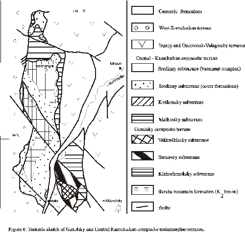
Metamorphic terranes. Not so far ago, metamorphic complexes have been considered by many geologists to be the Precambrian or Paleozoic basement underlying Mesozoic formations of Kamchatka [Shapiro,1976]. This point of view was based on the assumption about ancient age of metamorphic rocks, but it was not supplied by geological and reliable isotopic data. During the late 1980s and early 1990s, these complexes were shown to have conspicuous metamorphic and structural zoning. At the same time, their radiometric dating failed to yield ages older than Early Cretaceous [Vinogradov et al., 1991]. New geological materials revealed that large outcrops of metamorphic rocks have complex structure composed of metamorphosed sequences of different origin. We describe large outcrops of metamorphic rocks as Khavyvensky, Ganalsky, and Central Kamchatkan composite metamorphic terranes.
Central Kamchatkan composite metamorphic terrane consists of Sredinny, Kvahonsky and Malkinsky subterranes.
Sredinny subterrane, a lower structural unit of Central Kamchatkan composite terrane (Figure 6, figure 7), consists of granite-metamorphic complex (basement) overlain by non-homogeneously metamorphosed cover consisting of sedimentary and volcanic rocks.
This basement includes different gneisses and plagiogneisses intruded by granitoides. The Rb/Sr whole-rock age of the metamorphism in rocks of the basement yielded Neocomian dates of 127-116 Ma [Vinogradov et. al., 1988]. The lithology of metamorphic complexes indicates that protoliths of the metamorphic rocks were deposited as pelitic rocks with interbeds of tholeiitic basalt [Vinogradov et al.,1991].
The sedimentary cover consisting of argillite and sandstone unconformably rest on the basement. The basal conglomerate contains boulders and pebbles of crystalline schist and granite. The top of the sequence is composed of picrite basalt interbedded with tuff, chert, and tuffaceous sedimentary rocks. Presumably, the sedimentary covers have a post-Neocomian-Early Campanian age. The metamorphism of cover rocks varies from low-grade greenschist facies to staurolite subfacies. The greenschist metamorphism in the cover also as diaphthoresis in the basement of Sredinny terrane was connected with thrusting of the Malkinsky terrane in Early Campanian [Rikhter, 1995].
Kvahonsky subterrane overthrusted on Sredinny terrane from the west is overlain by Upper Cretaceous terrigenous formations of West-Kamchatka terrane. It consists mainly of Upper Jurassic-Lower Cretaceous volcanic rocks. The sequence is composed of dacite and basalt with interbeds of tuff containing tuffaceous terrigenous rocks with remains of plants in the top. The rocks were metamorphosed in thrust-fault zones from greenschist and blueschist facies of metamorphism but the age of the metamorphism is uncertain. Probably, it was Late Neocomian, the same as metamorphism in the basement of the Sredinny terrane. The rocks of the Kvahonsky terrane may be a fragment of Late Jurassic-Early Cretaceous island arc.
Malkinsky subterrane consists of series of tectonic nappes unconformably overlain by coarse-terrigenous rocks of Baraba Mountain Formation formed during Late Campanian-Maastrichtian in nonmarine, coastal and shelf environment. The tectonic sheets are often underlain by serpentinite melange. The lower parts of sequences in these sheets are composed of various tuffs, rare basalt and andesite flows of island-arc formation. Middle parts of sequences consist of terrigenous rocks similar to the sedimentary cover in the Sredinny terrane. The upper parts of sequences consist of siliceous and tuffaceous rocks. Presumably, the age of these formations is Early Cretaceous-Early Campanian. The rocks are metamorphosed from greenschist (in upper tectonic nappes) up to biotite-garnete or epidote-amphibolite schist (in lower nappes). Rb/Sr whole-rock age of latest metamorphism of the Malkinsky terrane is dated as 62 Ma [Grigoriev et al., 1991]. This event is possibly connected with thrusting of the Irunei terrane on Malkinsky terrane in Early Paleogene as well as thrusting metamorphism (chlorite subfacies) in Campanian-Maastrichtian rocks of Baraba Mountain Formation.
The formations of Malkinsky terrane are interpreted to have been formed in a back-arc basin with siliceous and tuff-terrigenous type of deep-sea sedimentation, near island arc.
Ganalsky composite metamorphic terrane includes Vakhtalkinsky, Stenovoy and Kizhechenoksky subterranes forming a package of tectonic nappes (Figure 7).
Vakhtalkinsky subterrane is a structurally lowest unit composed by metamorphic rocks from epidote-amphibolite to amphibolite facies. The lower part of sequence consists of metabasalt interbedded with rare chert, siliceous-manganese and ferro-manganese rocks that are overlain by terrigenous and siliceous-terrigenous rocks interbedded with effusive. Metabasalt (amphibolite) correspond to oceanic abyssal tholeiite and volcanics of oceanic islands. The upper part of sequence consists of calc-alkaline volcanics and terrigenous rocks with interbeds of chert and limestone [Zinkevich et al., 1993]. The formations of Vakhtalkinsky terrane are interpreted to have been part of an oceanic crust existed near island arc in Late Cretaceous time.
Stenovoy subterrane (intermediate tectonic nappe) is composed of volcanics, tuff, chert, and volcaniclastic rocks in lower part of section, and of terrigenous and tuff-terrigenous formation in the upper part of sequence. Volcanic rocks are represented by basalt, andesite-basalt, and rhyolite similar to bimodal island-arc association. The rocks are metamorphosed from greenschist to epidote-amphibolite facies and are intruded by numerous hypabyssal gabbro, quartz-diorite, and plagiogranite.
Kizhechenoksky subterrane is structurally highest tectonic nappe composed of metamorphic rocks of greenschist facies. The lowest sequence consists of basalt, tuff, and rare calc-alkaline rhyolite with interbeds of siliceous-manganese rocks. Overlapping terrigenous and siliceous and tuffaceous formations are similar to the sequences of the Malkinsky terrane. Kizhechenoksky terrane is supposed to have been formed in a deep-sea back-arc basin.
Metamorphism of rocks from greenschist to epidote-amphibolite facies increases downward in a structural section. The age of metamorphism is uncertain but it is possible, that tectonic overthrusting of above subterranes and their metamorphism took place in Early Campanian. The primary folds and thrusts had north-trending strikes with vergence to the west. The latest stage of deformations with forming of north-west trending folds, strike-slip faults, and thrusts and vergence to the northeast was connected with Early Paleogene accretion of Iruney and Ozernovsko-Valaginsky terranes. In this stage, plagiogranite (K/Ar date of 65 Ma) intruded between thrust sheets [German, 1978].
Khavivensky composite metamorphic terrane is exposed among Cenozoic deposits in the northern part of Central-Kamchatka graben. It consists of two subterranes composed of metamorphosed rocks from greenschist up to epidote-amphibolite facies. The structurally lowest subterrane consists of trachybasalt, trachydacite, chert, and tuff-terrigenous rocks formed in island arc environment [Litvinov, 1990]. The upper subterrane consists of metamorphosed tholeiite basalt, chert , and volcaniclastic rocks formed in back-arc or oceanic basin. 39Ar/40Ar dates of 55,2 Ma (upper subterrane) and 37,2 Ma (lower subterrane) support the idea about metamorphism during Early Cenozoic accretion [Zinkevich et al., 1993].
Kurile Island Arc
Kurile Island arc consists of the Great Kurile and Lesser Kurile Island chains separated off Pacific ocean by Kurile-Kamchatka trench.
Great Kurile Islands are composed of volcanics originated due to subduction of the Pacific plate. The oldest rocks recovered from this typical volcanic belt are of Neogene. The modern geophysical data [Ermakov et al., 1989, Zlobin, 1987] show that earth crust along Kurile arc has similar affinities and thickness (30-40 km). Granite layer exists in whole island arc but varies in the thickness and velocities of seismic waves.
The intensive volcanism occurred at Islands of the Great Kurile range in Miocene, Pleistocene and Recent time. The concentration of alkalic volcanics is higher in western part of Great Kurile than in eastern one that is corresponded with the depth to the Benioff zone. There is the zoning in the distribution of isotopes Sr along and across this island arc [Volynetz et al., 1988] and Ne and Sr [Zhuravlev et al., 1985]. Recent lavas contain 10 Be isotope that gives the evidence of the influence of modern sediments in the magma genesis of Kurile volcanic arc.
Great Kurile range is accompanied off Pacific side by nonvolcanic submarine range (Vityaz Rise), the southwestern part of which is the Lesser Kurile island chain exposed also at Hokkaido island, in Japan.
The Lesser Kurile range consists of Upper Cretaceous - Lower Paleogene mainly shallow-marine and subaerial volcanic, tuffaceous-sedimentary and terrigenous complexes intruded by mafic to siliceous sills and dikes [Gavrilov, Solov’eva, 1973; Streltsov, 1976; Melankholina, 1988; Parfenov et al., 1983]. The lower part of Cretaceous sequence is composed of volcanics of Matakotan suite overlain by tuffaceous and sedimentary rocks of Malokuril and Zelenovsk suites. Both complexes monoclinally dip to the south-west. At Shikotan island, complexly deformed tuffaceous and terrigenous rocks contain olistolithes composed of spilite, tuff, sandstone, and minor gabbro [Parfenov et al., 1983; Golionko and Kononov, 1993]. Melankholina [1988] reports about allochthonous layered gabbro at this island. The chemical affinities of volcanics from above complexes allow to divide them in two groups: (1) calc-alkaline basalt (lava flows) and gabbro (dikes) typical to island arcs [Parfenov et al., 1983; Simonov, 1992; and (2) gabbroides typical to oceanic crust [Parfenov et al., 1983].
Volcanic and intrusive complexes of Lesser Kurile chain were formed from Late Cretaceous to Early Paleogene in island arc environment on an oceanic basement. In modern framework of Kurile island arc, these complexes represent the terrane originated in island arc at 34-36,5o of northern latitude [Bazhenov, Burtman, 1993] and translated to present position until Early Eocene.
Okhotsk Basin: General Geology
The tectonic framework of the Sea of Okhotsk basin was discussed during long time [Markov et al., 1967; 1980; Gnibidenko, 1982; 1990; Belousov and Udintsev., 1981; Raznitzin, 1982; Kharakhinov et al., 1989; Savostin et al., 1983; ...], but before now a broad agreement on its composition and origin is absent.
Main Features of Sea of Okhotsk Bottom
The most part (40%) of the Sea of Okhotsk basin is shelf with depth up to 200 m and only 11% of its bottom has depth more 2000 m. On the north-west of this bottom, there is stretched from west to east the North-Okhotskan system of troughs divided by local structural rises. The large rift basin (TINRO) is situated between Kamchatka and P’yagina peninsula. Near Kamchatka, there is the West-Kamchatkan system of north-trending troughs. Large Institute of Oceanology and Academy of Sciences of USSR Rises divided by Makarov trough occur in the center of Sea of Okhotsk bottom and deep abyssal Deryugin, South-Okhotsk Basins present in its southern and western parts (Figure 1, figure 8).
Seismic refraction studies have revealed crustal thickness and velocities in different parts of the Sea of Okhotsk bottom that are typical to continental, subcontinental and suboceanic types of an earth crust [Markov et al., 1967]. The continental type characterizes the northern part of Sea of Okhotsk bottom, where the crust thickness is up to 28-32 km (the thickness of granite layer changes from 2 to 16 km). The subcontinental type of the crust occur in the central part of Sea of Okhotsk bottom (Institute of Oceanology and Academy of Sciences of USSR Rises). Suboceanic type with thickness up to 15-20 km (without granite layer) underlies South-Okhotsk Basin and Derugin Deep [Markov et al., 1980].
Okhotsk Arch is distinguished in the north-western Sea of Okhotsk bottom. It differs of another tectonic structures of Sea of Okhotsk bottom by its orientation, homogeneity of the sedimentary cover and basement as well as homogenous gravity and magnetic fields. The flat surface of the acoustic basement of Okhotsk Arch sometimes has minor folded structure that, probably, connected with marine volcanics. The thickness of Cenozoic cover usually does not prevail 1 km.
The Institute of Oceanology Rise is gently sloping tectonic unit with rounded form in center of Sea of Okhotsk bottom which rises 300-800 m above neighboring bottom. The surface of slopes is broken up by valleys, that are especially numerous near Derugin Deep slopes. The thickness of sediments at the top is up to 0,5 km increasing up to 2 km in lower parts of rise slopes.
Academy of Sciences of USSR Rise is large block (100 x 200 miles) bounded by a system of faults. Within the northwestern part of this rise, horst-like fault blocks form the Peter Schmidt trough; to the south, this rise terminates abruptly by South-Okhotsk Basin. The surface of the basement covered by sediments (the thickness up to 1 - 1,5 km) is broken by numerous faults. Volcanic cones, several forming knolls, and some completely buried by sediments, occur sporadically at south-eastern flanks of Institute of Oceanology and Academy of Sciences of USSR Rises. It indicates the existence in central Sea of Okhotsk during Early Cenozoic and latest Cretaceous of a former volcanic ridge, that was noted by [Zhuravlev and Protas, 1981; Krasnyi, 1983].
The most vast deep-sea basins of Sea of Okhotsk bottom are South-Okhotsk, Derugin and TINRO [Gnibidenko, 1990].
South-Okhotsk Basin is most deep depression with greatest depth of 3374 m. Its bottom represents abyssal plain dipping to the south-west [Belousov and Udintsev, 1981]. The sedimentary cover of this basin is composed of flat-lying Cenozoic deposits [Kharakhinov et al., 1989]. Oligocene - Lower Miocene complex was deposited during the intensive submergence (up to 2,5 km). Middle-Upper Miocene complex is formed in deep-sea basin with uncompensated sedimentation. Pliocene-Quaternary complex composed of widespread turbidites.
Derugin Deep consists of a number of deep troughs between Sakhalin to the west, Institute of Oceanology and Academy of Scienses of USSR Rises to the east and Okhotsk Arch to the northwest. The floor of Derugin Deep is flat in center raising to margins of this basin. The maximum depth of this basin 1795 m. The sedimentary cover is composed of minor dislocated Pliocene - Quaternary deposits, that smooth out the relief of the basement. [Zhuravlev, 1984., Kharakhinov et al., 1989] suppose Derugin Deep origin to be of Neogene - Quaternary age, but Raznitsin [1982] suggests that its origin have begun in the end of Cretaceous.
TINRO Basin extends more than 400 km long and up to 100 km width in northern Sea of Okhotsk between Siberia and Kamchatka. The boundaries of this Basin are not sharp and its sedimentary units continue toward western Kamchatka. The basin boundary correspond to isobath of 500 m, but greatest depth is 991 m. The eastern margin is formed by the faults along Kamchatka swell whereas faults in contact with Jurassic-Cretaceous accretionary complexes of Taigonos peninsula form its western margin. This Basin consists of a number northeast-trending troughs that are one-side grabens filled by Pliocene-Quaternary deposits. Seismic profiling and seismological data permit to conclude that Quaternary sediments were also subjected to fault deformations and riftogenic processes extending up to Holocene [Zhuravlev, Antipov, 1993].
Sedimentary Cover of the Sea of Okhotsk Basin
Sedimentary cover is widespread under the Sea of Okhotsk bottom and in neighboring areas. Compilation of seismic reflection profiles combined with geological mapping in onshore areas have delineated main features of the sediment stratigraphy, the sediment distribution, and structural fabric in the Sea of Okhotsk Basin [Zhuravlev, Antipov, 1993; Gnibidenko, 1990]. There is a considerable (up to 9 km) increase in sediment thickness of Cenozoic cover from the center of the Sea of Okhotsk bottom to its periphery. The thickness of individual seismic layers also changes in different parts of this bottom. The correlation of marine seismic and Cenozoic complexes within land is problematic and therefore there are different schemes of the seismic stratigraphy for sedimentary cover of the Sea of Okhotsk Basin. In this paper, we use the scheme by Zhuravlev and Antipov [1993].
Lower Cenozoic complex (Danian to Late Paleogene) is recognized better of all in TINRO and northern Okhotsk basins where it is studied by geological mapping, geophysical researches and core drilling in onshore area of Western Kamchatka. Marine seismic profiles demonstrate sharp change of this complex thickness that is primary controlled by topography of the bottom surface. In troughs with most full sequences, there are thickness of up to 6 km, but they are decreased at marine rises. The lower boundary of this complex very often is problematic. In Western Kamchatka, it includes thick (up to 4 km) terrigenous sequence of continental origin. This complex has very often folded-block structure. The age of this complex is based on the general correlation with onshore area but age of its lower parts is usually uncertain, especially for deep basins in south-western region.
Middle Cenozoic complex (Late Paleogene to Late Miocene) is recognized over most of Sea of Okhotsk Basin. Its greatest thickness is fixed near Sakhalin, in TINRO Basin, and near outer shelf of Western Kamchatka. It is typical cover complex that is especially well presented in seismic profiles of South Okhotsk Deep. In central parts of Sea of Okhotsk, it fills numerous small grabens. In Western Kamchatka and Sakhalin areas, this complex consists of marine and continental mainly thin-coarse sediments (siliceous claystone, opoke, diatomite). In central and southern Sea of Okhotsk, especially near Kurile island arc, it includes large amount of volcaniclastic rocks.
Upper Cenozoic complex (Late Miocene to Quaternary) is widespread in the periphery of Sea of Okhotsk bottom but often absent in its central part and at tops of anticline structures. It is composed mainly of thin-coarse terrigenous marine deposits over most part of the bottom and of volcaniclastic deposits in its southern and eastern parts. In Northern Sakhalin and its inner shelf, it composed mainly of sands. The greatest thickness of this complex (up to 6 km) is fixed at Sakhalin slope of Derugin Deep. In other parts of Sea of Okhotsk bottom, its thickness usually does not prevail 2 km.
The comparison of seismic sequences of Cenozoic cover in different tectonic units of Sea of Okhotsk bottom shows that a number of tectonic events took place in this region. In most cases, geophysical data provide supporting evidence for the long-time sedimentary hiatus between Cenozoic cover and underlying basement. An unconformity between the basement and Cenozoic cover is more clearly seen toward Sakhalin, Kamchatka, and Siberian coast, where it may be correlated with unconformity separating the Cenozoic sedimentary complex and folded basement [Gnibidenko, 1990]. It gives the evidence of active tectonic movements of Laramide phase [Zhuravlev and Antipov, 1993]. The Early Cenozoic time is characterized by the appearance of rifting structures. The structural unconformity between Upper and Middle Cenozoic seismic complexes shows the activity of tectonic movements in Late Miocene [Zhuravlev and Antipov, 1993]. The younger post-Pliocene structural movements may represent rejuvenation of movement along original lines of basement fabric, concomitant with the late Cenozoic rifting regime.
Sea of Okhotsk Basement
The conclusions about the composition and age of Sea of Okhotsk basement are based on tracing from land under the sedimentary cover of tectonic units of varying origin and age, on materials of dredging, and isotopic dating of dredged rocks.
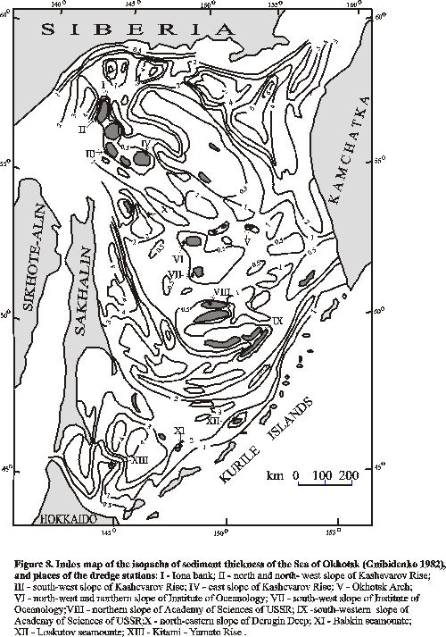
The outcrops of the Sea of Okhotsk basement are known in different parts of bottom [Figure 9]. Sedimentary, magmatic and metamorphic rocks [Table 1] were dredged from Kashevarov Arch, Academy of Sciences of USSR and Institute of Oceanology rises, lower part of South-Okhotsk Deep slopes [Geodekjan et al., 1976; Avchenko, 1987; Lelikov, 1992; Vasil’ev et al., 1984; Gnibidenko, 1990; Belousov and Udintsev, 1981; Gnibidenko and Iljev, 1976;].
Sedimentary rocks consist of arcose and greywacke sandstone, argillite, siltstone, slate, minor limestone, and siliceous rocks. The rocks of Institute of Oceanology Rise and of the southern part of Okhotsk Arch were, probably, formed from mafic volcanics, also as fine-grained rocks of Kashevarov Rise. But, sandstone of Kashevarov Rise was formed from Na-granitoides and metamorphic rocks [Lelikov, 1992]. The presence of arcose sandstones within the Okhotsk Arch gives the evidence of the erosion of sialic complexes. The rocks dredged from north-eastern Okhotsk Arch contain Cenomanian-Turonian fauna. The another sedimentary complex from this tectonic unit is supposed to be of Mesozoic age [Lelikov, 1992].
In the northern Sea of Okhotsk, the most part of the bottom is covered by thick sediments, but basement rocks were dredged from Okhotsk Arch and Kashevarov Rise.
The dredging from lower part of the south-eastern slope of Kashevarov Rise allowed to sample angular debrises of greenschist and ranging in size from pebbles to cobbles material including intermediate and siliceous tuff, andesite, quartz diorite, slate, siltstone, tuffaceous sandstone [Geodekjan et al., 1976]. From its south-western slope, it was recovered a great number of blocks of metamorphic (gneiss, granite-gneiss, amphibolite, minor quartz-biotite slate, and greenschist) and sedimentary (siliceous rocks, sandstone, siltstone, slate) rocks. Also, there are enough indurated sandstone, coal-bearing slates, and unindurated tuffaceous siltstone, argillite, and tuffaceous sandstone, as well as quartz diorite, granodiorite, granites, granite-porphyry, gabbro. To the east, from Kashevarov Rise it was recovered sedimentary rocks (clay, argillite, slate, siltstone, also as volcanic rocks (andesite, plagioandesite, dacite, rhyolite, minor basalt, andesitic basalt) and intrusive rocks (granites, minor granodiorite, and dolerite) [Vasil’ev et al., 1984]. Large blocks of jasper, meta-andesite, and albitophyre were dredged from south-eastern slope of Okhotsk Arch to the east of Kashevarov Rise [Vasil’ev, 1984].
The dredging of north-western and northern slopes of the Institute of Oceanology Rise allowed to sample large blocks and debrises composed of granodiorite, quartz granodiorite, rhyolite, schist, mica siliceous slate, phyllite, tuffaceous sandstone, and siltstone, minor biotite-hornblande gneiss [Geodekjan et al., 1976; Avchenko et al., 1987; Lelikov, 1992]. The dredging from south-western slope of this rise yielded diorite, granodiorite, granite, monthonite, also as pebbles of aplite, microdiorite, diabase, meta-andesite, meta-dacite, albitophyre, minor basalt, and andesite.
The dredging of the northern slope of Academy of the Sciences Rise yielded pebbles and debrises composed of magmatic (quartz-diorite, dacite, andesite, siliceous and intermediate tuff, minor diabase, rhyolite, granodiorite, gabbro) and sedimentary (arcose sandstone and siltstone) rocks [Geodekjan et al., 1976; Vasil’ev et al., 1984].
The central parts of the Academy of Sciences of USSR Rise, Institute of Oceanology Rise, and Kashevarov Rise are composed of weakly alternated intrusive rocks (diorite, granodiorite, granite, minor granosyenite, syenite, and gabbroides [Geodekjan et al., 1976; Vasil’ev et al, 1984] and volcanic rocks (basalt, andesite, rhyolite, dacite, and trachydacite, minor lavo-breccias and siliceous tuff) [Gnibidenko, 1990; Lelikov, 1992]. Metamorphic rocks (amphibolites and different gneisses) were dredged from Institute of Oceanology Rise and Okhotsk Arch, also as rocks from Iona bank, metamorphosed in greenstone facies (phyllite, meta-effusive, slate).
The major part of volcanic rocks is most probably of an island-arc origin. Chemical compositions of magmatic rocks of Institute of Oceanology and Academy of Sciences of USSR Rises have, mainly, calc-alkaline trends of differentiation similar to Upper Cretaceous volcanics of Eastern Kamchatka and Lesser Kurile Range [Geodekjan et al., 1976; Gnibidenko, 1990; Lelikov, 1992]. It is Cretaceous-Early Paleogene island-arc complex formed before Cenozoic cover formation.
The basalt and dacite dredged from Academy of Sciences of USSR Rise yield K-Ar dates of 149-117 Ma [Gnibidenko,1990]. Lelikov [1992] reports the dates from 115 to 41,1 Ma for effusives; he divides intrusive rocks in two groups: Cretaceous, from 130 to 78 Ma, and Cretaceous-Paleogene, from 100 to 31 Ma. Gnibidenko [1990] notes the dates of 209 ± 4 Ma for the granodiorite from Institute of Oceanology Rise.
The composition of the basement of South-Okhotsk Basin is poorly known. The dredging of western part of Kitami-Yamato Rise yielded debrises of amphibole-biotite granite, tuffaceous siltstone. From the Loskutov and Babkin seamountains (outcrops of the acoustic basement in south-western South-Okhotsk Basin), it was yielded also poorly indurated tuffaceous sandstone, siltstone, argillite. From Babkin seamountain, it was yielded large angular debrises of biotite-amphibole granite, andesite, andesitic dacite, minor basalt, andesitic basalt, and their tuffs as well as numerous fragments of intrusive rocks (quartz-diorite, plagiogranite, Bi-granites, granit-porphyr. The sedimentary rocks are represented by siltstone, arcose or polymict sandstone, diatomite, siliceous rocks. The similar rocks were yielded from northern slope of South-Okhotsk deep-sea Basin.
The composition of Derugin Deep basement is unknown, but dredging from its north-eastern slope yielded angular fragments of sedimentary rocks (partly indurated tuffaceous siltstone, quartz-feldspathic sandstone, siltstone, coal-bearing and siliceous argillite, graywacke) also as differently alternated intermediate and mafic volcanics and amphibole-biotite diorite, minor granodiorite, granite [Vasil’ev, 1984].
The detail description of magmatic and metamorphic rocks of the Sea of Okhotsk bottom was given by Lelikov [1992] and Avchenko et al., [1987]. They showed that protolite of metamorphic rocks was presented by volcanics and sedimentary rocks. The specific features of metamorphic rocks gave the evidence to the conception explaining their forming by the metamorphism of originally island arc volcanics. The isotopic determinations summarized in Table 1 revealed Cretaceous age of the metamorphism.
Geophysical data also as the distribution of metamorphic and magmatic complexes in the central part of Sea of Okhotsk bottom allows to suppose that Okhotsk Arch basement extends to Central Kamchatka. It is supported also mineral compositions and thermodynamic conditions of metamorphism of Kashevarov Rise rocks which are similar to those of Malkinskaya series in Sredinny Range of Kamchatka (Central Kamchatkan terrane) [Lelikov, 1992].
Magmatic and tuff-sedimentary complexes dredged of the north-trending chain of sea bottom rises (Kashevarov Rise, Institute of Oceanology and Academy of Sciences of USSR Rises) formed in island arc environment. It is possible, that island arc volcanics and metamorphic rocks of Institute of Oceanology and Academy of Sciences of USSR and Kashevarov Rises formed in the same paleo-island arc. But, it is possible also that Kashevarov Rise rocks formed in another island arc. The unhomogenous structure of the Sea of Okhotsk bottom is marked by varying age of a sedimentary cover in its different parts [Kharakhinov et al., 1989].
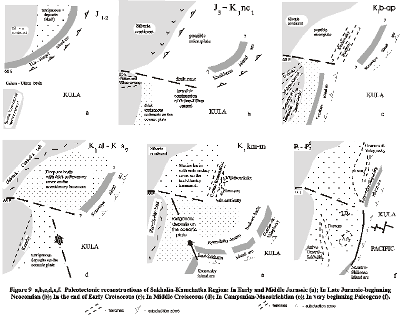
Tectonic Reconstructions and Discussion.
In previous sections, we have integrated modern geologic data on terranes of Kamchatka, Sakhalin and Sikhote-Alin to infer the geologic history of the Sea of Okhotsk region. The terrane analysis of above regions showes distinct paleotectonic connection between some terranes in the past. This connection is reconstructed for Sikhote-Alin and Hokkaido-Sakhalin systems of terranes, between Eastern composite terrane of Sakhalin and Central Kamchatka terranes, also as between terranes of Western Kamchatka and Siberia.
It allowes to test tectonic model explaining the formation of the Sea of Okhotsk framework as a complex process of long-time discrete accretion and coastwise translation interrupted by episodes of rifting and destruction. The geological interpretation, presented here, fits well with the relative motion vectors computed by Engebretson et al., [1985].
The model in Figure 9 begins with Jurassic Period because the pre-Jurassic geology is too uncertain to permit a meaningful map reconstruction.
In Early and Middle Jurassic, Mongol- Okhotsk paleoocean was between Siberia and Bureinsk-Khankaysky microcontinent. To the north, Uda-Murgal island arc existed at Siberian continental margin. In Late Jurassic, the closure of the Mongol-Okhotsk paleo-ocean occurred due to the collision of Bureinsk-Khankaysky microcontinent to Siberia that result in formation of vast landmass in the western part of this region [Khanchuk, 1993].
Pra-Pacific ocean was situated to the east and to the south off above new formed continent. The fragments of this oceanic basin are represented by most ancient oceanic assemblages of Sakhalin - interbedded chert, radiolarite, limestone, volcanics, and volcaniclastic rocks of Paleozoic and Triassic - Early Cretaceous age in Western, Central-Sakhalinsky, Langeriysky, Susunaysky, Nabilsky, and (as a numerous blocks) in the Anivsky, Gomonsky and East-Schmidtovsky terranes [Rikhter,1986].
The chert sequences in these terranes are specified by the absence of terrigenous material; stability conditions of deep-sea sedimentation during a long temporary interval; the low rate of sedimentation (400-500 m. for 130-140 Ma) comparable with that at modern abyssal plate; specific character of fossils (radiolarians, less often conodontes and fragments of siliceous sponges); the manganese mineralization. They are interpreted as parts of Paleozoic-Mesozoic sedimentary cover of abyssal parts of the oceanic plate. Langeriysky and Susunaysky terranes as well as Gomonsky, Anivsky and East-Shmidtovsky terranes include volcanic formations (fragments of oceanic volcanic rises). Gomonsky and Anivsky terranes comprise also interbedded carbonatous and volcanic rocks containing shallow-water fauna.
On the north, the Paleozoic and Mesozoic oceanic formations are exposed in terranes of Koryak accretionary system.
In the very beginning of Neocomian, the Kula plate was being subducted beneath Siberian margin and to the north along the Koryak and Beringian margins [Scholl et al., 1987; Scholl and Stevenson, 1989]. The chain of active volcanoes (Uda - Murgal belt) traced to the northeast to Koryak margin (Figure 10b).
The Omgon-Kvakhonsky island arc existed in the northeastern part of the region from Late Jurassic through Hauterivian time. The metamorphism and granitization took place in deep parts of this island arc. It is possible that a back-arc basin or minor plate was bounded by Omgon-Kvakhonsky island arc to the east and Murgal volcanic belt (island arc of Andyan type) to the west. The similarity between fragments of Omgon-Kvakhonsky island arc exposed in Omgon terrane and in the basement of the West Kamchatkan terrane and complexes of the same age in southern Koryak accretionary system [Bondarenko and Sokolkov, 1990] allowes to suppose that Omgon-Kvakhonsky island arc was a part of system of island arcs existed near Eurasia.
In Sikhote-Alin, the lateral variety of tectonic units consisted (from the west to the east) of Bureinsk-Khankaysky continent, Sikhote-Alin shallow-water basin and oceanic plate.
In the end of Early Cretaceous (Barremian-Aptian), Siberian continent have enlarged after intensive folding and microplate collisions. Kvakhonskaya island arc (Figure 11a) was disrupted and its nothern continuation was accreted onto continental margin. The general thickening of the crust and metamorphism in the northeastern part of the region took place 127 - 116 Ma ago, that is supported by mentioned above isotopic data on age of metamorphic rocks in the Sredinny terrane of Kamchatka. Later, it was a basement of deep-sea terrigenous sediments formed near continental slope of Siberia. The small Stenovaya island arc and back-arc basin appeared somewhere to the northeast. Sikhote-Alin accretionary system have been formed during docking onto Bureinsk-Khankaysky margin of Gorinsky, Nizhne-Amursk, Samarkinsky, Hungarian and Zhuravlevsky terranes. Kemsky island arc existed to the east.
It is likely, that this accretion episode occurred during the oblique subduction of oceanic Kula plate, because all terranes in Sikhote-Alin accretionary prism are displaced by left-lateral strike-sleep faults acted from Late Triassic to Recent time [Parfenov, 1984; Khanchuk, 1993].
In Middle Cretaceous, Okhotsk-Chukotsk volcanic belt, similar to recent Andean margin of South America, originated in the location of the Mesozoic Uda-Murgal island arc [Parfenov, 1984].
In Albian- Cenomanian time, the Kula plate underwent tectonic compression near Eurasia and Kemsky island arc was accreted onto Sikhote-Alin margin. The local blueschist facies metamorphism of metaophiolite and volcanic and sedimentary rocks of ocean crust took place 96-90 Ma ago in fault zone (Figure 11b).
In Late Cretaceous (Coniacian), the Kronotsk-Shipunsky island arc was generated somewhere to the south. Rock assemblages, and geochemistry affinities of volcanic rocks presented in Kronotsk-Shipunsky terrane in Kamchatka are similar to those of the Tonga-Kermadec island arc [Khubunaya, 1987]. Paleomagnetic data on Upper Cretaceous rocks of the Kronotsk-Shipunsky terrane are absent while the paleolatitude from Paleogene rocks is 41o ± 6oN [Bazhenov et al., 1992].
In Campanian - Maastrichtian time, the new island arc was generated in the northwest Pacific, extending from approximately 32o-55oN paleolatitude (Figure 12a). The fragments of this island arc are exposed in modern framework of Sea of Okhotsk region as Western Schmidtovsky and Kotikovsky terranes of Sakhalin (western segment of arc), as Ozernovsk-Valaginsky terrane of Kamchatka (eastern segment of this arc) and, likely, in the central part of Sea of Okhotsk (Institute of Oceanology and Academy of Sciences of USSR Rises). Rymniksky-Irunei back-arc basin or a minor plate must have existed between this island arc to the east and Eurasia margin to the west. In the northern part of this basin, deep-sea terrigenous sediments deposited on complex basement with accretionary framework (Central-Kamchatkan and Ganalsky composite metamorphic terranes). To the south, this basin is characterized mainly tuff-siliceous sedimentation because Irunei terrane in Central Kamchatka almost does not contain terrigenous sediments.
There are geologic constraints in this region on tectonic reconstructions for Campanian-Maastrichtian time. The reconstruction of the positions in the past of volcanic and sedimentary complexes of Campanian-Maastrichtian age from tectonic sheets of Kamchatka and Southern Koryak revealed the existence of vast transition zone of Western Pacific type. It is possible to find all complexes from shallow-water terrigenous assemblages (typical to Koryak continental slope) to deep-sea tuff-siliceous ones (Irunei back-arc basin) and to island arc volcanics (Ozernovsko-Valaginsky island arc). The general shortening of above transitional zone during attachment of this island arc onto Koryak margin composes not less than 1500-2500 km. It supports the model 2 of Geist et al., [1994] which postulates that ancient island arcs were generated in the periphery but not in the center of Pacific ocean and, later, were accreted onto continent margins and then were displaced along these margins by large-scale coastwise translation processes.
Paleomagnetic data provide important information on the originating latitude (40-430 N) of the Ozernovsko-Valaginsky segment of this island arc [Kovalenko, 1990; 1992; Savostin, Heiphetz, 1988]. Maastrichtian to Danian rocks of this arc (Karaginsky Island and Olyutorsky region) formed at 40o-45o N paleolatitude. In contrast, late Eocene rocks from the Olyutorsky region yield a paleolatitude of 61o, which is approximately its current latitude. These results confirm the conclusion that docking of the Ozernovsko-Valaginsky segment of this island arc finished to Late Eocene time.
Since the end of Cretaceous-very beginning Paleogene, after 85 Ma, the Kula plate was subducted along the ancient Beringian margin while the Pacific plate was subducted along the Eurasian margin [Engebretson et al., 1985]. This configuration remained somewhat the same up to 43 Ma when the Kula-Pacific spreading center died, although major shifts in the Euler poles occurred between 43-85 Ma [Engebretson et al., 1985]. Counterclockwise rotation of Kula-Pacific spreading between 55-56 Ma has been demonstrated by Lonsdale (1988) and thus, Kula plate motion during the Eocene is subject to some uncertainty. After 43 Ma, the Pacific plate was moving to the west-northwest subnormal to Eurasian margin with several shifts in the Euler poles up to the present time.
The tectonic framework of Sakhalin turned into the collage of different terranes and the main framework of this island was formed in the end of Cretaceous-very beginning Paleogene. The collision boundary between Anivo-Central-Sakhalinsky and Eastern terranes in Sakhalin is marked by greenschist facies metamorphic rocks with age 71-58 Ma (Langeriysky terrane).
In the northern part of the region, the collision of the Ozernovsk-Valaginsky island arc with Eurasia prior to northward transport provides an explanation for cessation of island arc volcanism in latest Cretaceous-early Paleocene time. Moreover, the cessation of Ozernovsk-Valaginsky island arc volcanism is coeval with the cessation of Okhotsk-Chukotka volcanism along the eastern Siberia margin [Belyi, 1994]. This collision leaded to the beginning of the closure of Irunei back-arc basin and to tectonic superposition of back-arc and island-arc complexes (West-Kamchatka, Iruney, Ozernovsko-Valaginsky terranes) in the northern part of Sea of Okhotsk region. This event is not dated in Central Kamchatka, but it is fixed in Oluytorsky region of Koryak highlands with the similar geology [Mitrofanov, 1977; Kazimirov et al., 1987].
Prior to the formation of the Aleutian Arc at about 55 Ma, the Kula and possibly Pacific plates were being subducted beneath Kamchatka. Formation of the Aleutian Arc is proposed to have been caused by the buckling of the fast-moving Kula plate at southern Alaskan margin [Scholl and Stevenson, 1989], possibly triggered by the accretion of the Ozernovsko-Valaginsky island-arc in the Olyutorsky region [Worral, 1991]. During the early history of the Aleutian Arc, the western terminus of the arc did not extend west past Shirshov Ridge and therefore, Pacific or Kula plate subduction continued during Paleogene time along the length of the Kamchatka and southern Koryak margin. The open corridor must have existed between Kamchatka and western terminus of the Aleutian arc according to the hypothesis about coastwise translation of Ozernovsko-Valaginsky island arc.
The history of Pacific and Kula plates best supports accretion of the Ozernovsk-Valaginsky paleo - island arc during latest Cretaceous - early Paleocene and northward translation ending at 43-50 Ma.
In Cenozoic, after accretion in the end of Cretaceous-very beginning of Paleogene, large-scale rifting processes appeared in whole region. They raised high amplitude block and rifting movements within the Sea of Okhotsk bottom and created main features of its modern tectonic framework. Raznitsin [1982] supposes that the formation of Derugin Deep continued in western part of the region as a result of this rifting process. Later, lower complex of sedimentary cover filled grabens in the bottom. The volcanic activity of Ozernovsko-Valaginsky island arc died out and newly formed Vetlovsky oceanic basin begun to be formed to the east (Figure 9).
It is possible, that it was connected with general change of Pacific plate movements resulted in a change of general compression to rifting in this region. The Euler pole change at 43 Ma for the Pacific plate resulted in a change from oblique convergence to sub-normal convergence along the Kamchatka margin [Engebretson et al., 1985] and is probably responsible for the widespread Eocene deformation episode and cessation of northward terrane motion. The time span when most of the coastwise translation took place was between the end of the formation of the Ozernovsk-Valaginsky island arc (latest Cretaceous) and 43 Ma. Structures in the Olyutorsky region indicate that the Koryak mountains provided a buttress to margin-parallel motion (ending 50 Ma), although southward along the eastern Kamchatka margin, coastwise translation may have continued until late Eocene time.
The very intensive tectonic compression in Middle Eocene led to final closing of the Iruney basin also as to closure of Vetlovsky marginal basin with formation of Vetlovsky collision suture, that was overlapped later (Oligocene to Miocene) by clastic deposits of the Tyushevsk Cenozoic Basin. The attachment of Kronotsko-Shipunsky arc fragments and Kamchatka Cape terrane to Kamchatka also apparently had occurred to middle Eocene. Coastwise translation appears to be the most likely mechanism for the bringing the Kronotsko-Shipunsky island arc terrane from 40oN-55oN to its present position. Most of the coastwise translation took place 43-66 Ma ago.
A considerable overall increase in the crystal thickness and thus augmentation of the continental block took place in this time. The intensive metamorphism occurred in the lower part of the crust during of the tectonic superposition of different sequences, that is demonstrated in Khavivensky metamorphic terrane of Kamchatka.
Coastwise translation of Ozernovsko-Valaginsky island arc until Middle Eocene requires that strike-slip faults must have been present along the Kamchatka peninsula during Paleogene time. Moreover, these faults would have to be inboard to transport the Late Cretaceous rock exposed in the eastern ranges of Kamchatka. The great amount of coastwise translation at speeds similar to Pacific or Kula plate speed during Paleogene also suggests that a transform, rather than subduction, boundary separated the continental and oceanic plates along the Kurile-Kamchatka margin. Ancient strike-slip or transform faults have not been mapped on Kamchatka. However, geological mapping in Eastern Kamchatka revealed that all Cretaceous complexes, interpreted as fragments of the Ozernovsko-Valaginsky island arc, are obliquely displaced along their trends. These displacements may be the evidence of the oblique underthrusting combined with strike-sleep fault activity in early Paleogene. The supposed faults, inactive since Eocene time, would be mostly concealed by younger volcanic belts and terrigenous sediments. In addition, prevalent crystal shortening in Miocene time would have overprinted deformation associated with an earlier episode of strike-slip faulting and coastwise translation. Such a major strike-slip fault zone is evident to the south along the Sikhote-Alin margin where left-lateral terrane displacement continued in Cenozoic [Parfenov, 1984; Natal’in and For, 1991].
Presumably after the 43-Ma change in Pacific plate motion [Engebretson et al., 1985] along the westernmost Aleutian Arc caused the western terminus to migrate toward Kamchatka, eventually resulting in pervasive strike-slip faulting in the western part of the Aleutian Arc [Baranov et al.,1991; Geist et al.,1988]. This change is likely to have been responsible for the creation of the Komandorsky transform faults, in western Aleutian Arc. This system of faults, providing westward translation of the Aleutian arc unit and its attendant collision with Kamchatka, must not have existed before a northern part of the Ozernovsko-Valaginsky island arc was trapped in the Komandorsky Basin.
After 43 Ma, dominantly sub-normal convergence of the Pacific plate beneath Kamchatka and subduction north of the Aleutian Arc associated with Komandorsky Basin spreading between 10-20 Ma may have provided the driving force for a second, Miocene phase of thrusting and uplift to expose the already accreted island arc. This episode of thrusting on Kronotsky Peninsula and Kamchatka Cape may be heavily influenced by the subduction of sea floor features with substantial relief, such as Obruchev rise. Accretion of Obruchev Rise and convergence of the Aleutian arc to Kamchatka uplifted and exposed the offshore part of the island arc assemblage in Miocene time.
After Middle Eocene episode of terrane accretion, new-formed continental block was destroyed by the tension resulting in appearance of volcano-plutonic belts and grabens. The most vast Koryak-Central Kamchatkan volcanic belt (P2?-3-Q1) was formed by the volcanics of basalt-trachyite-comendite series geochemically similar to those of intracontinental and marginal-continental belts [Volynets et al., 1990].
In Oligocene, Kurile Island arc appeared and traped the Sea of Okhotsk Basin. Seafloor spreading occurred in the Komandorsky Basin during Miocene time [Baranov et al., 1991] also as in Derugin Deep and South Okhotsk Basin [Gnibidenko, 1990].
Late Miocene intensive compression episode leaded to the complication of the tectonic framework in Kamchatka. Thrusting of the Ozernovsk-Valaginsky terrane on sedimentary strata of Cenozoic Tyushevsk Basin was most prominent tectonic event in this time. Other Kamchatka terranes were re-exposed through contractional uplift in this time. The role and meaning of the middle Miocene compression are problematic for the Sea of Okhotsk bottom. Possibly, that the structural unconformity between Upper and Middle Cenozoic seismic complexes indeed shows the activity of tectonic movements in Late Miocene.
The appearance in Late Miocene of East Kamchatkan volcanic belt (N2-Q) finally created tectonic structure of Kamchatka very similar to modern one. In Pliocene-Quaternary time, substantial uplift of the region occurred episodically, accompanied by high-amplitude block movements. In Sakhalin, rifting in the Tatarsky Strait result in thrusting of terrigenous complexes (Western Sakhalin) on Miocene deposits (central part of island) and forming of the modern framework of this island.
At this same time, as Seliverstov [1987] has shown, the continental border of Kurile-Kamchatka trench continued to increase as a result of the attachment and tectonic reworking of adjacent parts of the Pacific plate. The zones of compression were displaced to the eastern part of the region, apparently in connection with the process of the subduction of the Pacific Ocean crust in Kurile-Kamchatka and Aleutian trenches.
Conclusions
1). Kamchatka and Sakhalin consist of the terranes of varying age and origin. Most of terranes are large tectonic units, composed of complexes of almost the same age, corresponding to the environment of an island arc and adjacent parts of back-and fore-arc basins in Late Mesozoic time. These widespread terranes show close facies relations to neighboring terranes in the past. Reconstruction of terrane positions in the past allow to restore ancient transitional zones of West Pacific type. But, some terranes are exotic because they differ off main tectonic framework by age and origin.
2). Available data show a remarkable similarity between complexes at large outcrops of the crust basement in the Sea of Okhotsk and terranes of Kamchatka and Sakhalin. Okhotsk Arch extended to central Kamchatka, where it is exposed as Central Kamchatka metamorphic terrane. Institute of Oceanology and Academy of Sciences of USSR Rises are composed of island arc complexes similar to East Sakhalin composite terrane and to Ozernovsko-Valaginsky terrane of Kamchatka. It allows to suppose that the most part of the Sea of Okhotsk basement is composed of accreted terranes the same as Kamchatka and Sakhalin ones.
3). The terrane accretion is the main process of the crust production in the Sea of Okhotsk region. The earth crust forming of Sea of Okhotsk region began since the Late Mesozoic. The accretion episodes took place in Albian-Cenomanian, Campanian, in latest Maastrichtian - early Paleocene, in Middle Eocene, in Late Miocene, and in Pliocene. The accretionary episodes followed by rifting events formed tensional structures - volcanic belts, grabens, also as rifting depressions with newly formed oceanic crust. The activity of tectonic movements displaced in time from Siberia continent to Pacific ocean.
4). The sequence of events proposed for the formation, transport, emplacement, and post-emplacement deformation is directly related to plate motion history in the northwestern Pacific Ocean. The formation of paleo-arc-trench systems took place far to the south near continental margins. A considerable overall increasing of northern Eurasia associated with accretion in the Pacific periphery and coastwise translation along continental margin. Each of these events can be related to the direction of convergence of the Pacific plates.
Acknowledgments. This research described in this publication was made possible in part by grant N 59300 from the International Science Foundation and Russian Government. We thank dr. Yury N. Raznitsin and prof. Anatoly D. Chekhov for many valuable comments and suggestions. We also thank Mikhail P. Antipov and Boris V. Baranov for useful discussion.
Bazhenov, M.L., V.S. Burtman, O.A. Krezhovskhkh, and M.N. Shapiro, Paleomagnetism of Paleogene rocks of the Central-East Kamchatka and Komandorsky Islands: tectonic implications, Tectonophysics, 201,157-173, 1992.
Baranov, B.V., N.I. Seliverstov, A.V. Murav’ev, and E.L. Mazurov, The Komandorsky basin as a product of spreding behind transform plate boundary, Tectonophysics, 199, 237-269, 1991.
Belousov, V.V. and G.B. Udintsev (Editors), The structure of Sea of Okhotsk bottom (in Russian), Moscow, Nauka press, 176 p, 1981.
Belyi, V.F., The Okhotsk-Chukchi volcanogenic belt: geology and development, in International Conference on Arctic Margins. September 6-10, Abstracts., Magadan, Russia, p.14, 1994.
Bogdanov, N.A., V.D. Chekhovich, A.N. Sukhov, and V.S. Vishnevskaya, Tektonics of Olutorsky zone (in Russian), in Outlines of tectonics of Koryak highlands, Moscow, Nauka press, pp. 189-217, 1982.
Bondarenko, G.Ye. and V.A. Sokolkov, New data on the age, structure and development of volcanogenic-chertous-sedimentary complex of Omgon Cape Western Kamchatka (in Russian), Trans. (Doklady) Akad. Nauk SSSR, 315, (6), 1427-1434,1990.
Chekhov, A.D., S. A. Palandgzan, Tectonics of Taigonos peninsula ophiolites, (in Russian), Tikhookeanskya Geologia, N 6, 25-32, 1994.
Chekhovich, B.D., Tektonics and geodynamics of the folded rim of little oceanic basins (in Russian), Moscow, Nauka press, 272 p, 1993.
Chikov, B.M., Structure and evolution of the Okhotian Median Massif (in Russian), in Tectonics of Siberia, vol.4, Moscow, Nauka-press, pp.74-81, 1970.
Dobretsov, N.L., T. Watanabe, B.A. Natal’in, and S. Miyashita, Comparison of ophiolites and blueschists of Sakhalin and Hokkaido, Ofioliti, 19 (1), 57-176, 1994
Engebretson, D.C., A. Cox, and A. Gordon, A., Relative motions between oceanic and continental plates in the Pacific Basin, Geol. Soc. Am. Spec. Pap., 206, 59 p.,1985.
Ermakov, V.A., A.I. Levykin, and T.K. Zlobin, Composition and structure of the earth crust and mantle in Kuril islands (in Russian), Izv. Akad. Nauk SSSR, Phizika Zemli, 10, 18-37, 1989.
Geist, E.L., T.L. Vallier, and D.W. Scholl, Origin transport and emplacement of an exotic island-arc terrane exposed in eastern Kamchatka, Russia, Geol. Soc. of Am. Bull., 106 (9), 1182-1194, 1994.
Geodekyan, A.A., G.B. Udintsev, B.V. Baranov,A.F. Beresnev, K Berk, O.M.Bogatikov, V.V. Gabov, G.S. Gnibidenko, D.I.Dmitriev, L.P.Zonenshain, N.A.Kurentsova, Yu.N. Raznitsin, G.B.Rudnik, N.M.Suchevskay, Bed rocks of the Central Sea of Okhotsk Bed (in Russian), Sov. Geol., 6, 12-31, 1976.
German, L.L., Ancient crystalline complexes of Kamchatka. Moscow, Nedra, 128 p., 1978.
Gnibidenko, G.S., Main features of tectonics Sea of Okhotsk (in Russian), in Geological structure of the Sea of Okhotsk Region. Vladivostok, pp. 3-21, 1982.
Gnibidenko, G.S., Rift system of the Sea of Okhotsk floor, in Asian Marine Geology Proceeding of the First International Conference on Asian marine geology, Sept.7-10, 1988, Shanghai, edited by Wang Pinxian and Lao Qiuyang, pp.73-82, China Ocean Press, 1990.
Golionko B.G. and Kononov M.V., Composition and structural position of the chaotic complex on the Shikotan island (Lesser Kuril Islands) in.: L.P.Zonenshain memorial Conference on Plate Tectonics. Programme and abstracts. pp. 64-65., 1993.
Grannik, V.M., Upper Cretaceous volcanogenic-sedimentary formations of the East-Sakhalin mountains ( in Russian ), Moscow, Nauka, 164 p., 1978.
Grigor'ev, V.S., and R.V. Lobzeva, Sr-isotops and age of the metamorphism of black slates in Sredinno-Kamchatsky massive (in Russian), Litol. i polez. iskop., 3, 127-131, 1993.
Ishiga, H. and Ishiyama, D., Jurassic accretionary complex in Kaminokuni terrane, south-western Hokkaido, Japan, Mining Geology, 36 (3), 381-394, 1987.
Iwata, K. and I. Tajika, Jurassic and Cretaceous radiolarians from the pre-Tertiary system in the Hidaka Belt, Maruseppu region, Notheast Hokkaido, J. Fac. Sci. Hok. Univ., ser. IV, 22 (3), pp. 453-466, 1989.
khanchuk, A.I., Geological structure and development of North-West Pacific continental rim (in Russian), Ph.D. dissertation, 30 pp., Far-East Geol. Inst., Vladivoctok, 1993.
Kharakhinov, V. V., Terecshenkov, A. N., Baboshina, V. A., Pudikov, E. G., Tectonics of sedimentary basins Sea of Okhotsk Region : Moscow (in Russian), VNIIEKGAZProm, 31 p., 1989.
Kazimirov, A.D., K.A. Krylov, and P.I. Fedorov, Tectonic evolution of marginal basins, based on South Korjak highland example (in Russian), in Outlines of geology of North-Western sector of Pacific tectonic belt, Moscow, Nauka-press, pp. 200-225, 1987.
Khubunaya, S.A., High-alumina plagio-tholeiite facies of island arcs (in Russian), Moscow, Nauka press, 167 p., 1987.
Kiminami, k. and Y. Kontany, Mesozoic Arc-Trench Systems in Hokkaido, Japan, in Accretion Tectonics in the Circum-Pacific Regions, edited by M.Hashimoto and S. Uyeda, pp.107-122, Terra Scientific, Tokyo, 1983.
Kimura, G., S. Miyashita, and S. Miyasaka, Collision Tectonics in Hokkaido and Sakhalin, in Accretion Tectonics in the Circum-Pacific Regions edited by M.Hashimoto and S. Uyeda, pp.123-134, Terra Scientific, Tokyo, 1983.
Kochergin E.V., Anomalous magnetic field of Pacific ocean neighboring to southern Kurile islands (in Russian), Trudy Sakhalin kompl. nauch. Inst., vol. 38, Yuzhno-Sakhalinsk, pp. 63-73., 1975.
Kosminskaya, I.P., S.M. Zverev, P.S. Veytsman, and Yu.V. Tulina, General features of the earth crust composition in transition zone (in Russian), in Earth crust composition in Asia continent - Pacific ocean transition zone, pp.75-91, pp.179-219., Moscow, Nauka press, 1964.
Kovalenko, D.V., Paleomagnetic research of island arc complexes of Olutorsky zone, Karaginsky Island and results of tectonic interpretation (in Russian), Geotectonics, Engl. Transl., 2, 92-101, 1990.
Kovalenko, D.V., Paleomagnetism in the Paleogene Suites of the Il'pinskiy Peninsula, Kamchatka, Geotectonics, 408-421, 1992.
Krasnyi, M.L., A system of paleo-island arcs in North-Eastern Asia (in Russian), in Composition and dynamics of transitional zones (Abs.), Sochi, p.165, 1983.
Kropotkin, P.N. and Shakhvarstova, K.A., Geological framework of the Pacific mobile belt (in Russian), M., Nauka press, 356 p., 1965
Lelikov E.P., Metamorphic complexes of the marginal seas of Pacific (in Russian). Vladivostok, Dalnauka, 168 p., 1992.
Lonsdale, P., Paleogene history of the Kula plate: Offshore evidence and onshore implication: Geol. Soc. of Am. Bull., v. 100, 733-754, 1988.
Litvinov A.F. Geology of the southern part of the Litke depression (Eastern Kamchatka) (in Russian), Ph. dissertation, 25 p., VSEGEI, Leninggad, 1990.
Markov, M.S., V.N. Averjanova, I.P. Kartashov, I.A. Solovjeva, and A.S. Shvaev, Mesozoic-Cenozoic history of the Earth’s crust within the Sea of Okhotsk region (in Russian), Moskow, Nauka press, 221 p.,1967.
Markov, M.S., Yu.M. Pushcharovsky, S.M. Tilman, V.S. Fedorovsky and N.A.Shilo (Editors), Tectonics of the Continental Margins of the North-West Pacific (in Russian), Moscow, Nauka press, 258 p., 1980.
Melankholina, E.N., Tectonics of North - West Pacific: ocean structures - continental margins relationships (in Russian), Trans. GIN Akad. Nauk SSSR, vol. 434, Moscow, Nauka press, 216 p., 1988.
Mitrofanov, N.P., Vatynsky tectonic nappe in Central-Koryak folded zone (in Russian), Geol. i geof., 4, 144-149, 1977.
Miyashita, S., and T. Katsushima, The Tomuraushi greenstone complex of the Central Hidaka Zone: contemporaneous occurrence of abyssal tholeite and terrigenous sediments, J. Geol. Soc. Japan., 92 (8), 535-557, 1986.
Natal’in, B.A., and For, M., Geodynamics of Asian margin in Mesozoic (in Russian), Tikhookean. Geol., 6, 3-23, 1991.
Nekrasov, G.E., The tectonics and magmatism of the Taigonos peninsula and North-West Kamchatka (in Russian), Trans. GIN Akad. Nauk SSSR, vol.280, Moscow, Nauka press, 159 p., 1976.
Nokleberg, W.J., Parfenov, L.M., and Monger J. W. H., and Baranov, B.V., Byalobzhesky, S.G., Bundtzev, T.K., Feeney, T.D.,Fujita, Kazuya, Goadey, S.P., Grantz, Arthur, Khancvhuk, A.I., Natal’ in, B.A., Natapov, L.M., Norton, I.O., Patton, W.W., Plafker, George, Scholl, D.W., Sokolov, S.D., Sosunov, G.M., Stone, D.B.,Tabor, R.W., Tsukanov, N.V., Vallier, T.L. and Wakita, kolji, Circum - North Pacific tectono - stratigraphic terrane map. U. S. Department of the Interior, U.S. Geological Survey. Open - file report 94, 216 p., 1994.
Okada, H., Collision Orogenesis and Sedimentation in Hokkaido, Japan, in Accretion Tectonics in the Circum-Pacific Regions, edited by M.Hashimoto and S. Uyeda, pp. 91-105, Tokyo, 1983.
Okada, H., Ando, K. and Nakaseko, K., Discovery of Aptian radiolarian fauna from the Kumaneshiri Group, Hokkaido, News Osaks Micropaleont. Spec., 5, pp. 359-360, 1982.
Parfenov, L.M., The continental margins and island arcs of the Asia Mesozoides (in Russian), Novosibirsk, Nauka, 191 p., 1984.
Parfenov, L.M., V.A. Popeko, and L.I. Popeko, Main structural-composition complexes in Shikotan island and their geological nature, Lesser Kuril islands, (in Russian), Geol. i geof., 10, 24-34, 1983.
Raznitsin, Yu. N., Ophiolite allochtonous and adjacent deep-sea basins in the west Pacific (in Russian), Trans. GIN Akad. Nauk SSSR, vol.371, Moscow, Nauka press, 105 p., 1982.
Rikhter, A.V., Structure and tectonical development of Sakhalin in Mesozoic (in Russian). Trans. GIN Akad. Nauk SSSR, vol.411, Moscow, Nauka press, 92 p., 1986.
Rikhter A.V., Structure of the metamorphic complex of the Median Kamchatka massif (in Russian), Geotectonics, no.1, 71-78, 1995.
Rozhdestvensky V.S.,Evolution of the Sakhalin fold system, Tectonophysics, no. 127, pp. 331-339., 1986
Savostin, L.A., and A.M. Heiphetz, Paleomagnetism of Maastrichtian- Paleocene complexes in Olutorsky zone, Southern Koryak (in Russian), Leningrad, VNIIGRI, pp.127-140, 1988.
Savostin, L.A., L.P. Zonenshain, and B.V. Baranov, 1983. Geology and plate tectonics of the Sea of Okhotsk, in Geodynamics of the Western Pacific-Indonesian Region, edited by T.W.H.Hilde, and S. Uyeda, Geod. ser., Vol.11., Washington, pp. 189-221, 1983.
Scholl, D.W., T.L. Vallier, and A.J. Stevenson, Geologic evolution and petroleum geology of the Aleutian Ridge: in Geology and Resourse Potential of the Continental Margin of Western North America and Adjacent Ocean Basins-Beaufort Sea to Baja California, edited by D.W. Scholl, A. Grantz, and J.G. Vedder, pp. 123-155, Circum-Pacific Council for Energy and Mineral Resources, Houston, Taxas, Earth Science Series, v. 6, 1987.
Scholl, D.W., and A.J. Stevenson, The Aleutian-Bowers-Shirshov system, response to deformation of Alaska (“Orocline”) by subduction-driven impact and escape of crustal masses-Exporation of an idea [abs.], EOS, Transactions of the American Geophysical Union, v.70, 1307, 1989.
Seliverstov, N. I., Seismoacoustic study of Transitional zone (in Russian), Moscow, Nauka press, 112 p. 1987.
Shantser, A.E., M.N. Shapiro, A.V. Koloskov, A.I. Chelebaeva, and V.N. Sinel’nikova, Evolution of the structure of Lesnovsky outcrop (Northern Kamchatka) and neighboring area in Cenozoic (in Russian), Tikhookean. Geol., 4, 66-74, 1985.
Shapiro, M.N., P.V. Markevich, V.I. Grechin, and E.A. Konstantinovskaja, Upper Cretaceous and Lower Paleogene sandstone in Kamchatka: composition and problem of their source (in Russian), Litol. i polez. iskop., 6, 94-106, 1992.
Sidorchuk, I.A., and A.I. Khanchuk, Mesozoic glaucophane schists of western edge in Central Ridge in Kamchatka (in Russian), Geol. i geof., 3, pp. 150-155, 1981.
Simonov, V.A., ophiolite petrogenezis (in Russian), Novosibirsk, Nauka press, 247 p., 1992.
Strel’tsov, M.I., Dislocations of southern part of Kurile island arc (in Russian), Moscow, Nauka press, 132 p.,1976.
Terekhov, M.I., Stratigraphy and tectonics of southern part of Omolon massif (in Russian), Moscow, Nauka press, 114 p., 1979.
Tilman, S.M., and N.A. Bogdanov, Tectonic map of the Northeast Asia. Scale 1:5,000,000, edited by Yu. M. Puscharovsky, Moscow, 1992.
Tsukanov, N.V., Tectonic development of Kamchatka onshore zone in Late Mesozoic-Early Cenozoic, Moscow (in Russian), Trans. GIN Akad. Nauk SSSR, vol.462, Nauka press, 102 p.,1991.
Tsukanov, N.V., A.V. Fedorchuk, and A.F. Litvinov, Oceanic complex of Shipunsky peninsula (in Russian), Dokl. Akad. Nauk SSSR, 318 (4), 958- 962, 1991.
Vasiliev, B.I, A.G. Zhiltsov, A.A. Suvorov, Geological structure of south-western Kurile system: island arc - trench (in Russian), Moscow, Nauka press, 106p.,1979.
Vinogradov, V.I., Grigor'ev, V.C. and Leytes A.M., Age of the metamorphism of the Kamchatka Median ridge(in Russian), Izvestia AN SSSR., Ser. Geol., no.9,.30-38., 1988.
Vinogradov, V.I., V.C. Grigor'ev, and V.M. Kastrykina, Age of metamorphic rocks of the Kamchatka basement (in Russian), Sov. Geol., 7, 58-64, 1991.
Volynets, O.N., V.S. Antipin, A.B. Perepelov, and G.N. Anoshin, Geochemistry of the volcanic series of an island-arc system applied to Kamchatka geodynamics (in Russian), Geol. i geof., 5, 3-13, 1990.
Volynets, O.N., V.S. Antipin, V.I. Vinogradov, and V.S. Grigor’ev, Sr-isotope zonation in quaternary laves of Kurile island arc (in Russian), Tikhookean. geol., 1, 19-27, 1988.
Vorogushin, N.T., Tectonical development of the southern part of Koryak highland in Paleogene (in Russian), Bull. Mosk. obsch. ispit. prir., 678 (1), 32-41,1992.
Watson, B.F. and K. Fujita, Tectonic evolution of Kamchatka and the Sea of Okhotsk and implications for the Pacific basin, in Tectonostratigraphic terranes of the Circum-Pacific region, edited by D.G.Howel, Houston, CPCEMR, pp.333-336, 1985.
Worrall, D.W., Tectonic history of the Bering sea and the evolution of Tertiary strike-slip basins of the Bering Shelf, Geological Society of America Special Paper 257, 120 p., 1991.
Zinkevich, V.P., A.V. Rikhter, and M.M. Fugzan, 40Ar/39Ar age of metamorphic rocks in Eastern Kamchatka (in Russian), Dokl. Akad. Nauk SSSR, 333 (4), 477-480, 1993.
Zinkevich, V.P., E.A. Konstantinovskaja, N.V. Tsukanov, A.V. Rikhter, V.D. Kamenetskiy, L.V. Danushevskiy, A.L. Sobolev, and S.A Garanina, Accretionary tectonics of Eastern Kamchatka (in Russian), Moscow, Nauka, 272 p., 1993.
Zinkevich, V.P. and N.V. Tsukanov, Accretionary tectonics of Kamchatka, Intern. Geol. Rev., 35, 953 - 973, 1993.
Zinkevich, V.P., S. Yu. Kolodayzhniy, L.G. Bragina, Ye.A. Konstantinovskaya and P.I. Fedorov, Tectonics of the eastern rim of the Central Kamchatka metamorphic massif (in Russian), Geotektonika, 6, 80-98, 1993.
Zhuravlev, A.V., and M.P. Antipov, Sea of Okhotsk area of submergence (in Russian), in Seismostratigraphic research in Eurasia. Proceeding of seismostratigr. section., vol. 2, Moscow, Nauka press, pp.160-184, 1993.
Zhuravlev, A.V. and Ya.N. Protas, The distribution of thickness and features of tectonic structure of cenozoic sedimentary complex in Sea of Okhotsk region, in: Relief and structure of the sedimentary cover in Far East basins (in Russian). Vladivostok, Far East Sci. Center AN USSR, pp.5-14, 1981.
Zhuravlev, D.Z., A.A. Tsvetkov, and A.Z. Zhuravlev, N.G. Gladkov, I.V. CVhernyshova, Lateral variation of Ne and Sr iszotope relations in Quaternary lavas of Kuril island arc and their petrological significance (in Russian), Geokhimiay, 12, 1723-1736, 1985.
Zlobin, T.K., New data on the composition of central part of Kurile island arc (in Russian), Dokl. Akad. Nauk SSSR, 293 (1), 185-188, 1987.
Figure 1. Tectonic scheme of Sea of Okhotsk Region.
Continental frame:
Post-Accretionary assemblages: 1 - sedimentary rocks (N2-Q); 2 - 8 - volcanic belts: 2 - Okhotsk-Chukotsk (K1a-K2sn); 3 - Udsko-Murgal (T3 - K1); 4-5 - East-Sikhote-Alin (4-N1-Q; 5-K2sn-P1); 6 - East-Kamchatka (N2-Q); 7 - Central-Kamchatka (P3-Q1); 8 - West-Kamchatka-Koryak (P2-N1);
North-western frame of Sea of Okhotsk: 9 - Siberian craton, 10 - Okhotsk massif, 11 - Balygichansky massif, 12 - Omolon massif, 13 - Taigonos massif, 14 - Verkhoyansky folded belt;
Mongol-Okhotsk accretionary system of Paleozoic - Jurassic age. Terranes: 15 - Galam; 16 - Ulban;
Sikhote-Alin accretionary system of Jurassic - Early Cretaceous age. Terranes: 17 - Gorinsky; 18 - Nizhne-Amursk; 19 - Samarkinsky; 20 - Hungarian; 21 - Zhuravlevsky; 22 - Kemsky;
Hokkaido-Sakhalin accretionary system of Cretaceous - Cenozoic age. Terranes: In Hokkaido: 23 - Oshima-Rebun; 24 - Sorachi-Yezo; 25 - Hidaka; 26 - Tokoro; 27 - Nemuro; In Sakhalin: 28 - Western; 29 - Anivo- Central Sakhalinsky; 30 - Eastern;
Koryak-Kamchatka accretionary system of Cretaceous - Cenozoic age. Terranes: 31 - Kuyulsky; 32 - Omgon; 33 - West-Kamchatka; 34 - Central-Kamchatka; 35 - Ganalsky; 36 - Khavivensky; 37 - Irunei and Ozernovsk-Valaginsky; 38 - Vetlovsky; 39 - Kamchatka Cape; 40 - Kronotski-Shipunsky;
Sea of Okhotsk bottom:
41 - South-Okhotkan basin; 42 - Derugin Deep; 43 - rises: Institute of Oceanology (I.O.) and Academy of Sciences of USSR (A.S.); 44 - Okhotsk Arch; 45 - faults (a - normal fault; b - fault, hachures on downthrown side); 46 - deep sea trench; Basins and trough: I - Tinro; II - Makarov; III - Peter Schmidt;
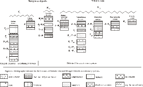
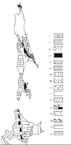
Figure 3. Terranes of Sakhalin and Hokkaido.
Sakhalin: 1 - Western; 2-4 - Anivo-Central-Sakhalinsky composite terrane: 2 - Central-Sakhalinsky (1) and Mereisky (4); 3 - Gomonsky (2) and Anivsky (5); 4 - metamorphic: Langeriysky (3) and Susunaysky (6); 5-9 - Eastern composite terrane: 5 - Nabilsky; 6 - island-arc: Kotikovsky and West-Shmidtovsky; 7 - Rymniksky; 8 - Elisavetinsky; 9 - East-Shmidtovsky; 10 - postaccretional complexes of Sakhaline; Hokkaido: 11 - Oshima-Rebun; 12 - Sorachi-Yezo: a-nonmetamorphic; b-Kamuikotan metamorphic complex; 13 - Idonnappu and nonmetamorphic Upper Cretaceous sequinses; 14 - Hidaka: a-nonmetamorphic; b-Hidakd metamorphic complex and Poroshiri meta-ophiolite; 15 - Tokoro; 16 - Nemuro;